Tory Island – Timeless and Tantalising❤️

Tory Ferry at Magheroarty

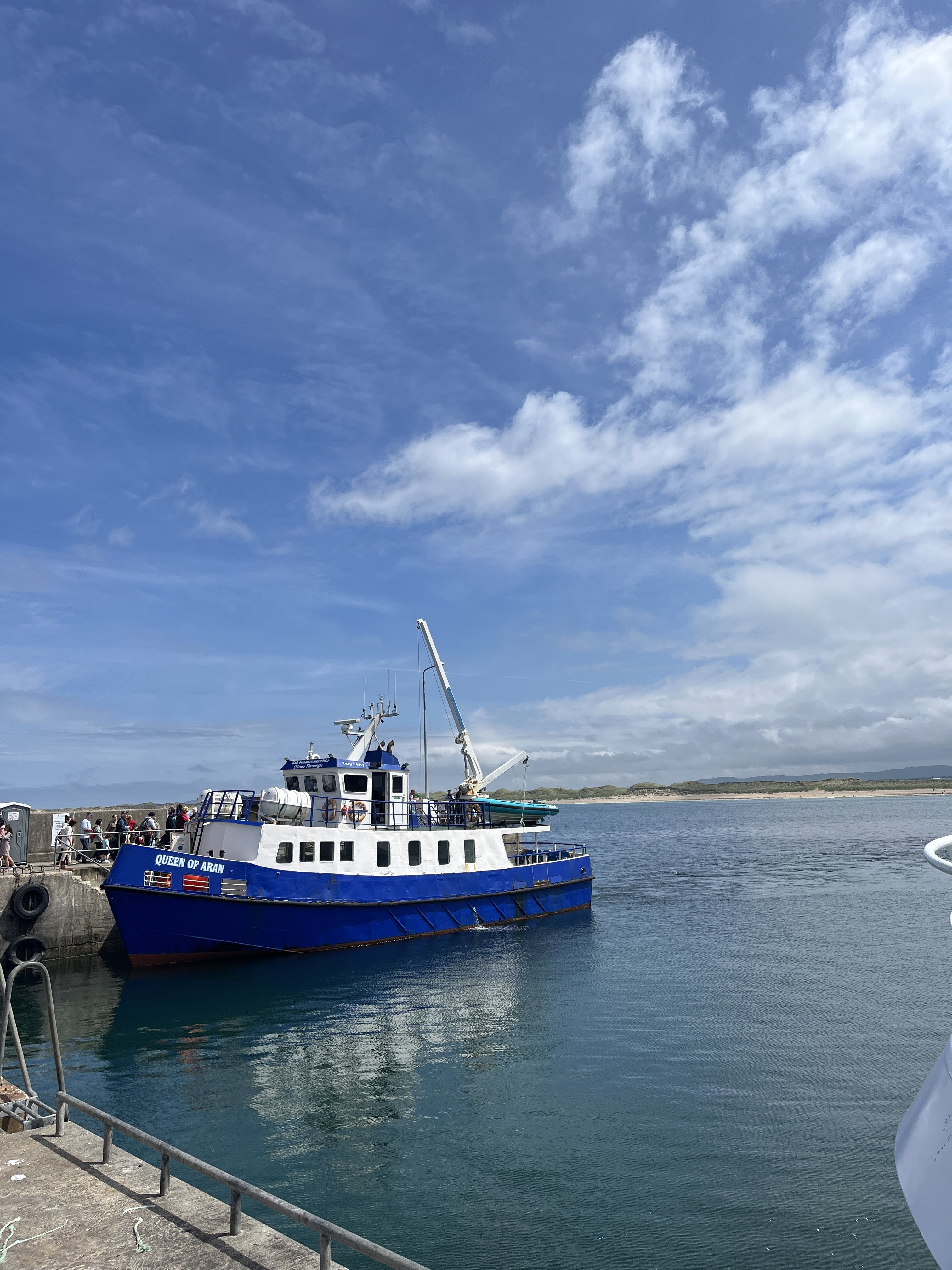
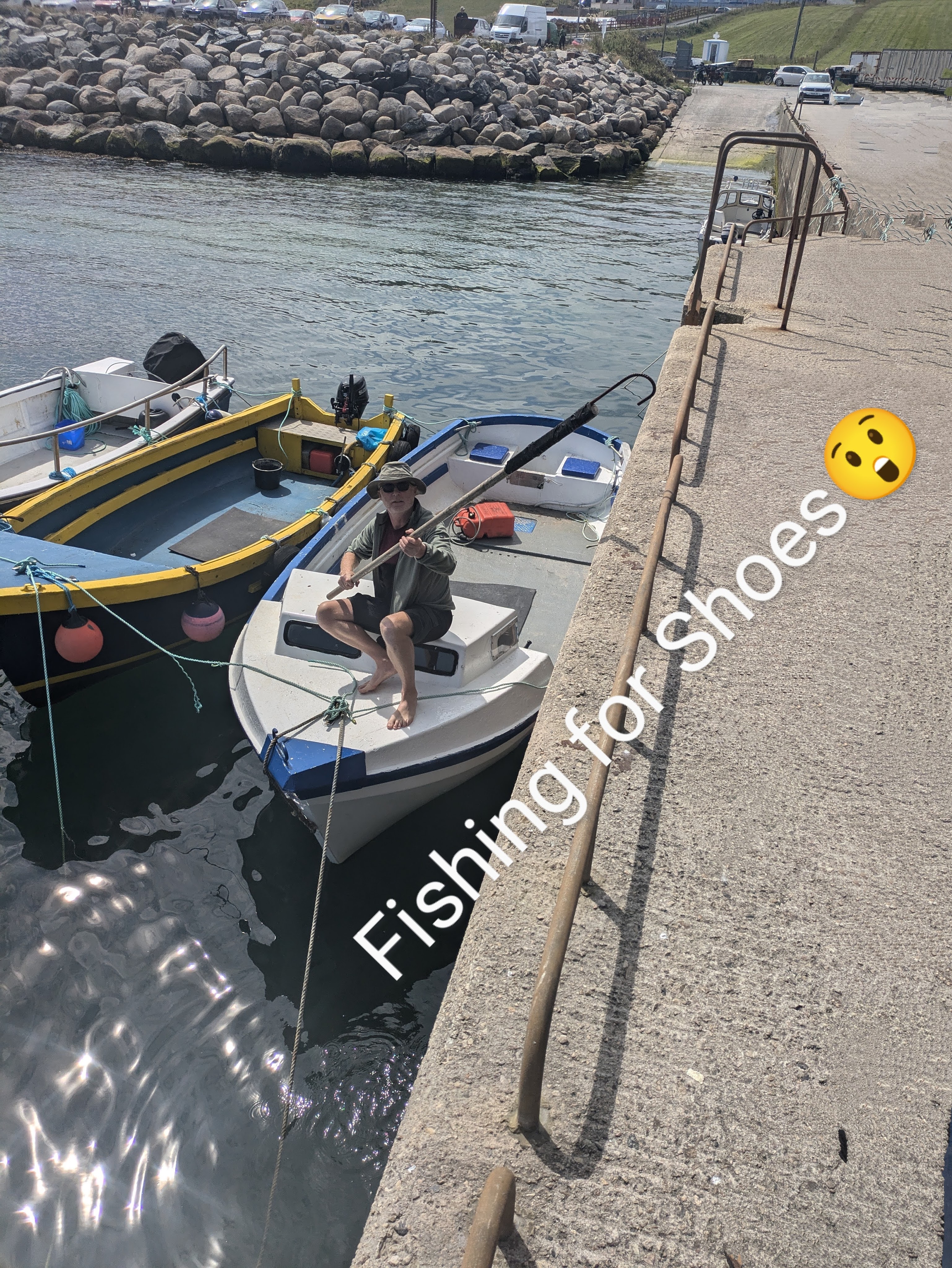
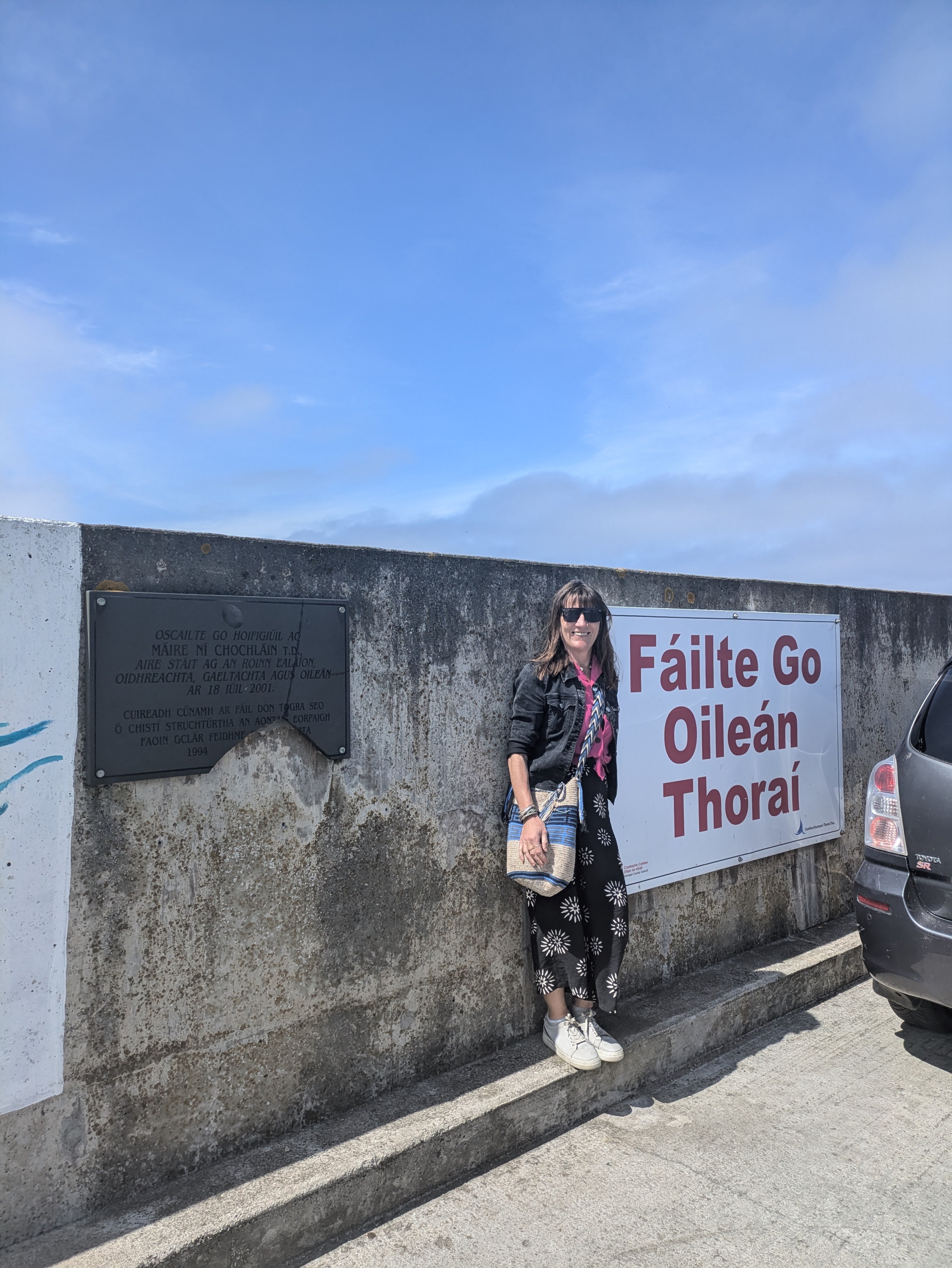
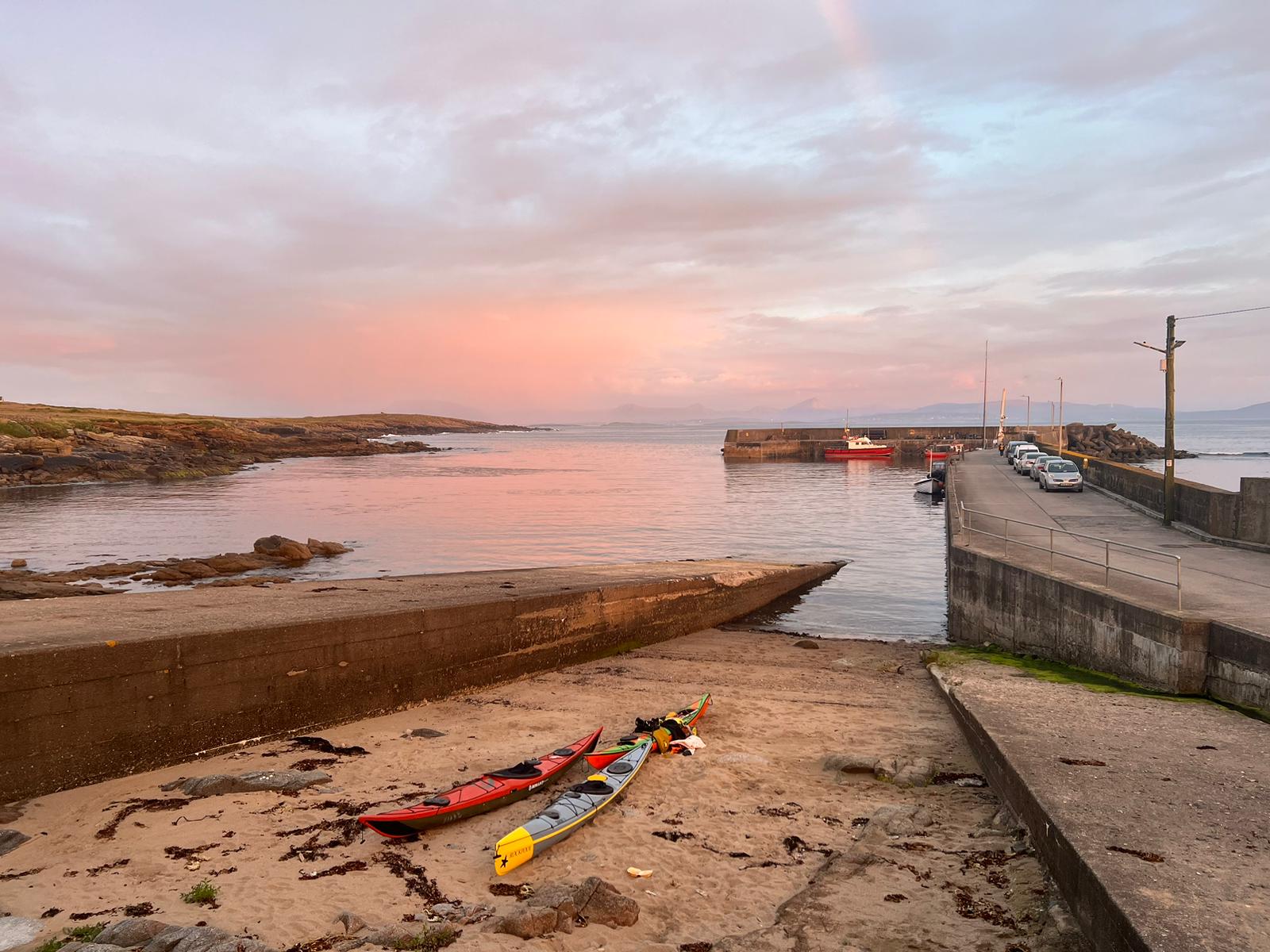
On a sunny July Sunday, we parked our van in Magheroarty in North West Donegal and walked down the pier to the small passenger ferry to take us to Tory Island, the most remote inhabited island off the Irish coast.  We were laden down with bags, mainly of rattling provisions (i.e. wine😀) for our three night/four day stay on the island. Although we had read online that there was a shop on Tory, it was recommended to bring as much as possible with us.  As we walked to the boat, Caoimhin kicked his sandal vigorously to release a pebble lodged under his foot – a little too forcefully because the sandal sailed into the air and landed in the water where it bobbed with the seaweed 😮. He ran down the pier steps to where a small  boat was moored, grabbed a hook and managed….eventually… to fish his footwear out of the water just before the ferry departed.

After that excitement, the boat journey was uneventful. We had booked our ferry tickets online the previous week for the 1pm crossing but we could have bought them at the little office on the pier. There was plenty of space on the boat, the inside seating area was virtually empty, most people opting to sit or stand at the railing outside on the deck. The boatman told us that the first sailing in the morning from the Margheroarty pier and the last sailing in the evening from the island were the busy ones as most visitors were day trippers.  

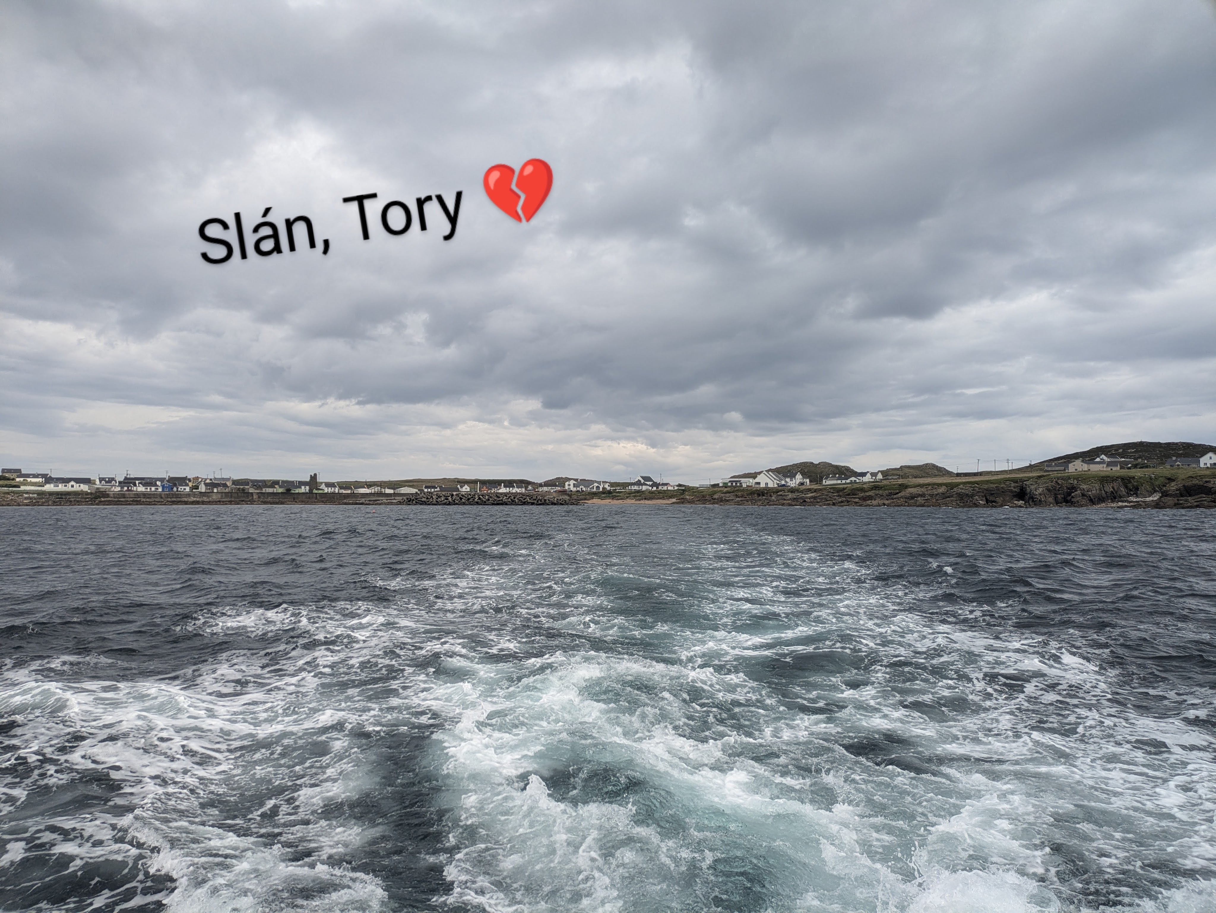
The  fourteen and a half kilometer journey took forty five minutes and luckily for us, the wind was light and the sea was glass-smooth, not always the case.  There was a time in the 1970s when the island was completely cut off for eight long weeks due to continuous storms and tumultuous seas. Some islanders left after that harsh winter to set up home on the mainland, only the hardiest and most resilient can survive out on the very edge of the world.

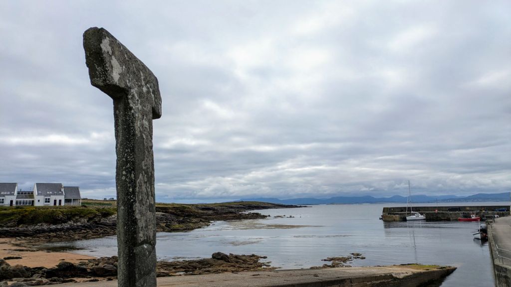
 The Donegal coast was still visible when we disembarked on the island but the mainland felt faraway, as if we had arrived in a remote timeless place. A couple of men were mending fishing nets in the harbor under the shadow of a Tau Cross,  a large ‘T’  shaped structure made of a single slab of mica slate and a form of crucifix  associated with early  Greek Church.  As mica slate is not  found on the island, the cross must have been made elsewhere and brought to the Island sometime during the 12th century. Over the years it has become a symbol of indestructibility and it is the custom to pray to it for protection before heading out to sea.

Silhouetted against the blue sky and visible from the harbor was the round tower, all that remains of the monastery founded by St Colmcille in the 6th century. It was evident that a variety of visitors have been coming to Tory since the earliest times, saints and scholars, pirates and adventurers, artists and fishermen. Although we now regard the offshore islands as very isolated places, in an earlier era when transport was by sea, they were actually the centers of commerce and learning where goods and ideas were traded and it was the mainland that was a forbidding densely-forested, barely penetrable place.

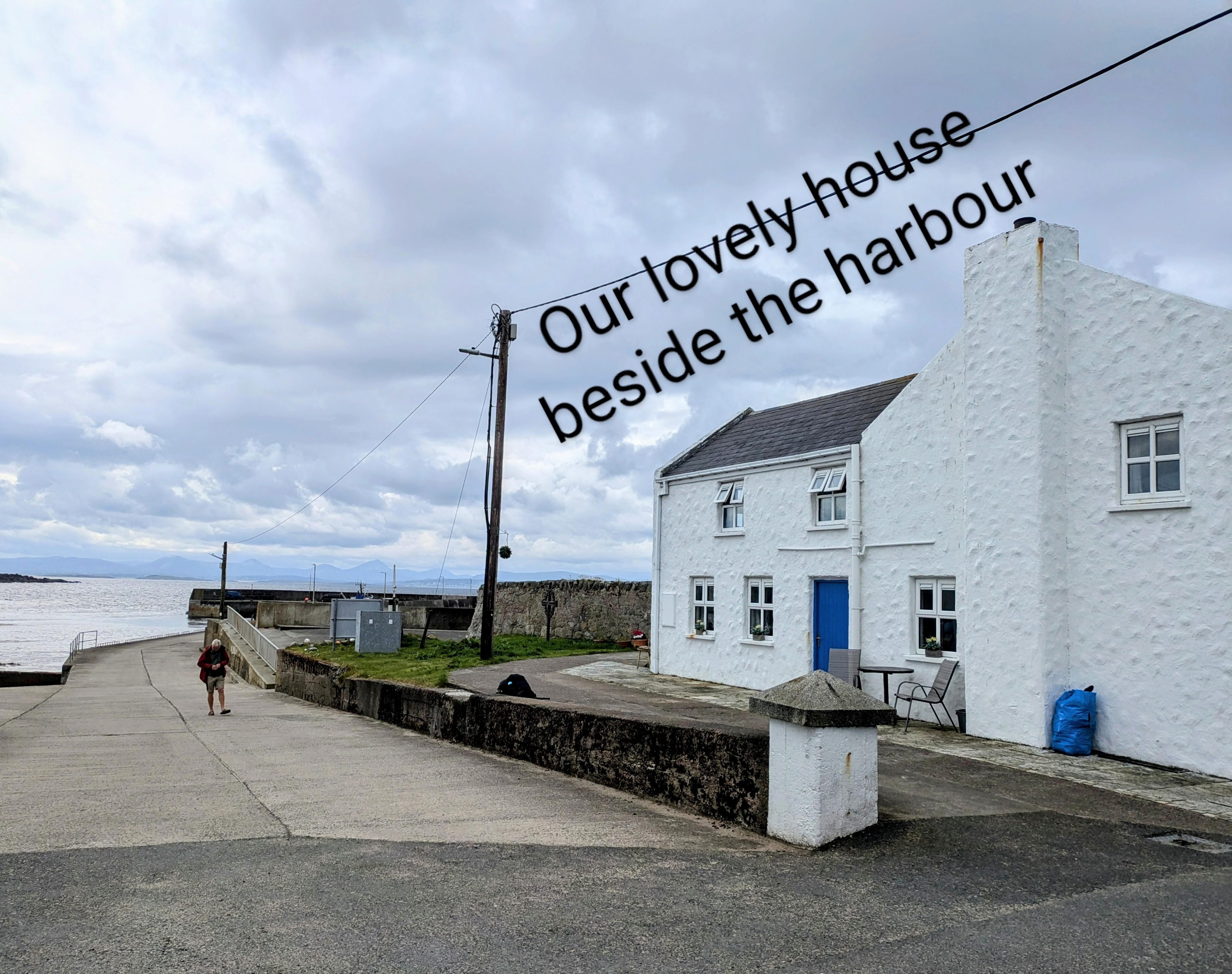
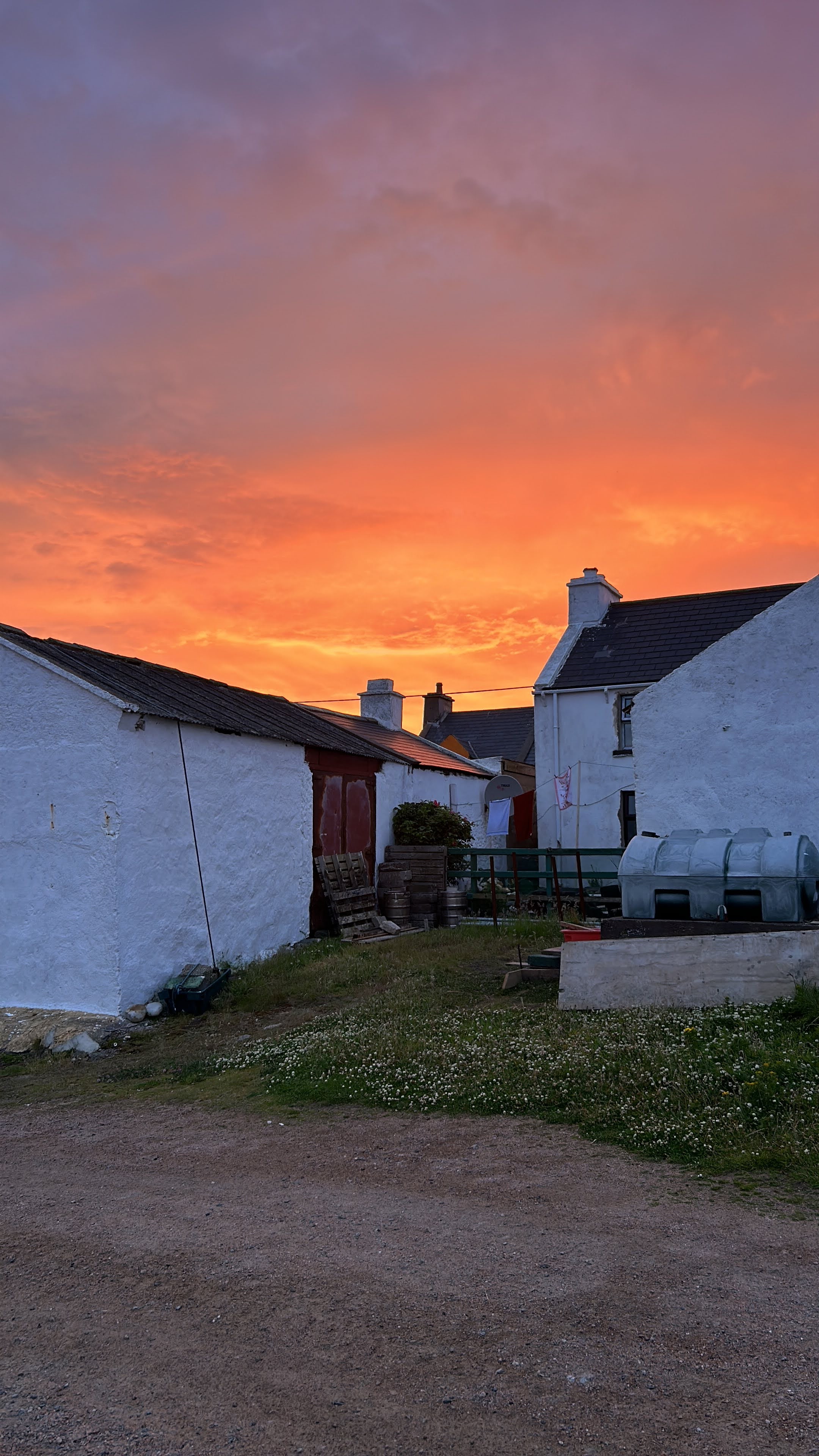
Our Airbnb was a stone’s throw from the slipway where the ferry docked in Baile Thiar (West Town), which was convenient for hauling our heavy bag of clinking luggage.  Our large bedroom window looked out both over the sea and the walled graveyard, nice juxtaposition of life and death. Four of us stayed in the rented house and the other five stayed in the Tory Island Hotel (Óstán Thoraí) which was two minutes’ walk away and overlooked both the pier and a sandy beach.

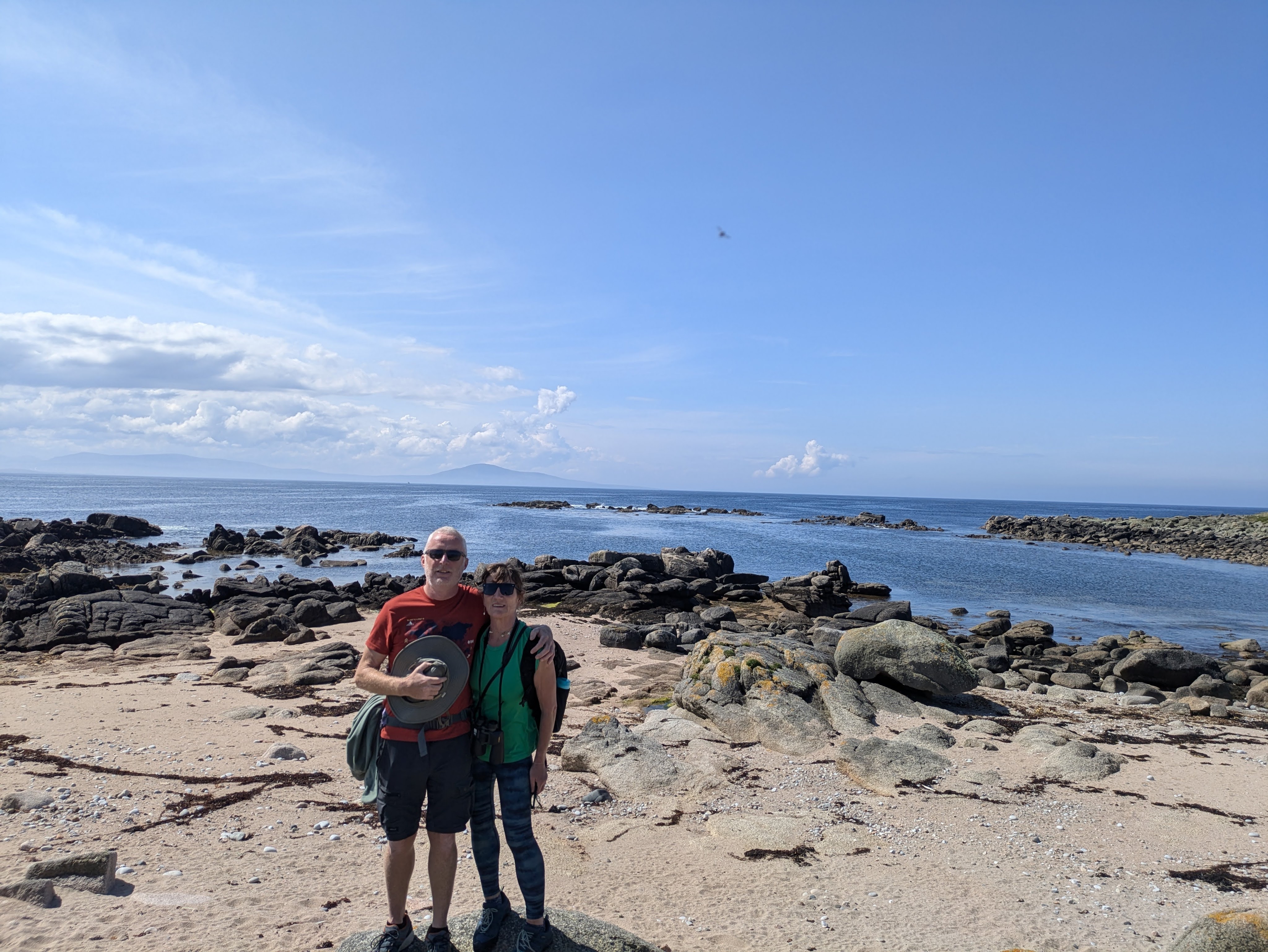
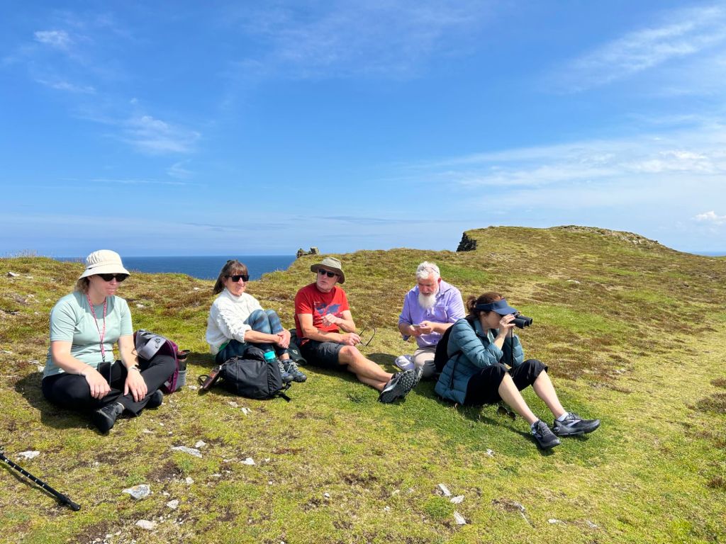
This was the first visit to the island for all nine in our group and we were really lucky with the weather. Locals told us that we had arrived on the first fine day of the year and the sunshine continued during our visit with spectacular sunsets until our last day when clouds rolled in and there was a spattering of rain.

Tory is a small island, about three kilometers long and a kilometer wide flanked by high sea cliffs at the eastern end (Tor Mor) and a lighthouse at the flatter western end. At the last census (2022) the population was 141 but it has a secondary school with a total of five  pupils. An expected intake of four additional pupils in first year this September will be a big boost.  Baile Thiar where we stayed has the largest center of population with the hotel, church, craft shop and a grocery store which  also doubled as the post office. Most other houses are clustered  in Baile Thoir (East Town)with an occasional house dotted around elsewhere.

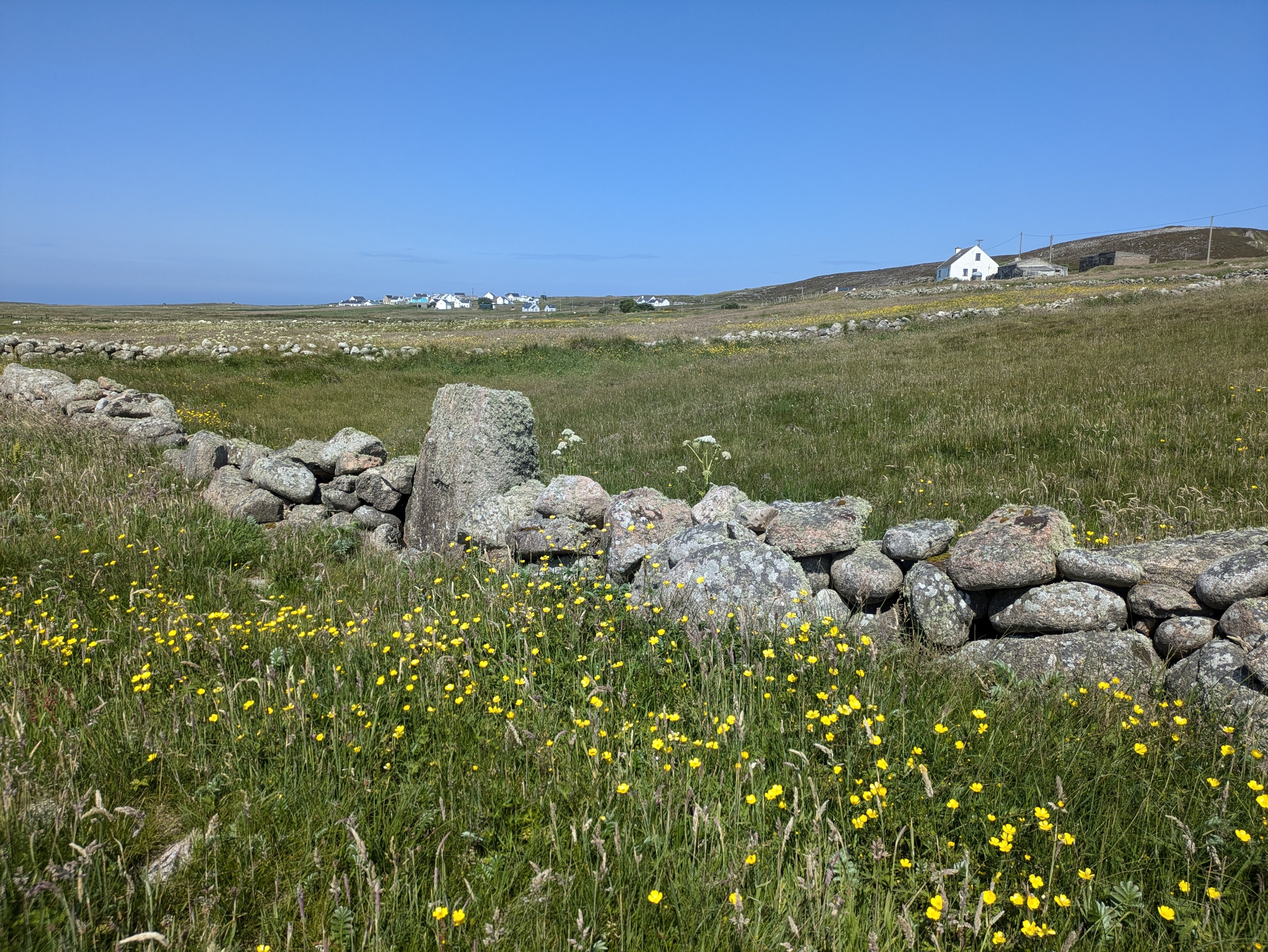
Tory Island is a paradise for birds and wildlife.  Although it is virtually treeless because of the high winds, there was a myriad of grasses and colorful wildflowers, orchids, heathers and an abundance of biodiversity.  Rabbits scampered in the early morning and evenings, a pair of swans and a raft of ducks swam on the lakes. The human population may be small, but the bird population is huge with large colonies of gulls, terns, pipits and oystercatchers. It is an important breeding ground for corncrakes, from now on I will always associate their distinctive call, so like a creaking door, with Tory.   We could even hear it from our kitchen table and it is a sound which has virtually disappeared from the rest of the country.

Bird Watching on Tory in Sunshine

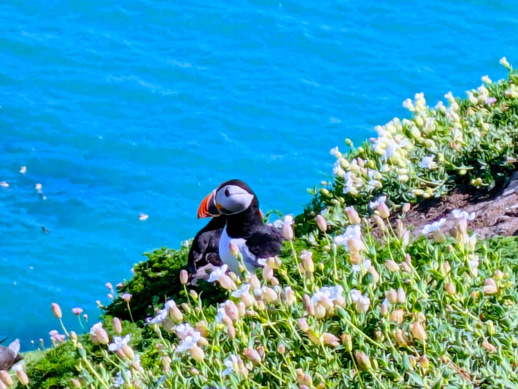
At the eastern end of the island, we spent a couple of hours watching hundreds of puffins on the grassy slopes beyond a rock called the Wishing Stone. It seemed to be  flight school  for the young  pufflings, it was hilarious watching the aborted take-offs and the crash landings on the cliff.

After exploring the island on foot, we took to the seas and hired a boat for a trip around the island which departed from the harbour at West Town. Our captain was also the only farmer on the island, rearing  sheep at the eastern end of the island.  He was accompanied by his two young grandsons, one who attended the island  primary school and the other in secondary school. The family spoke Irish together but switched seamlessly to lilting English when chatting to us.

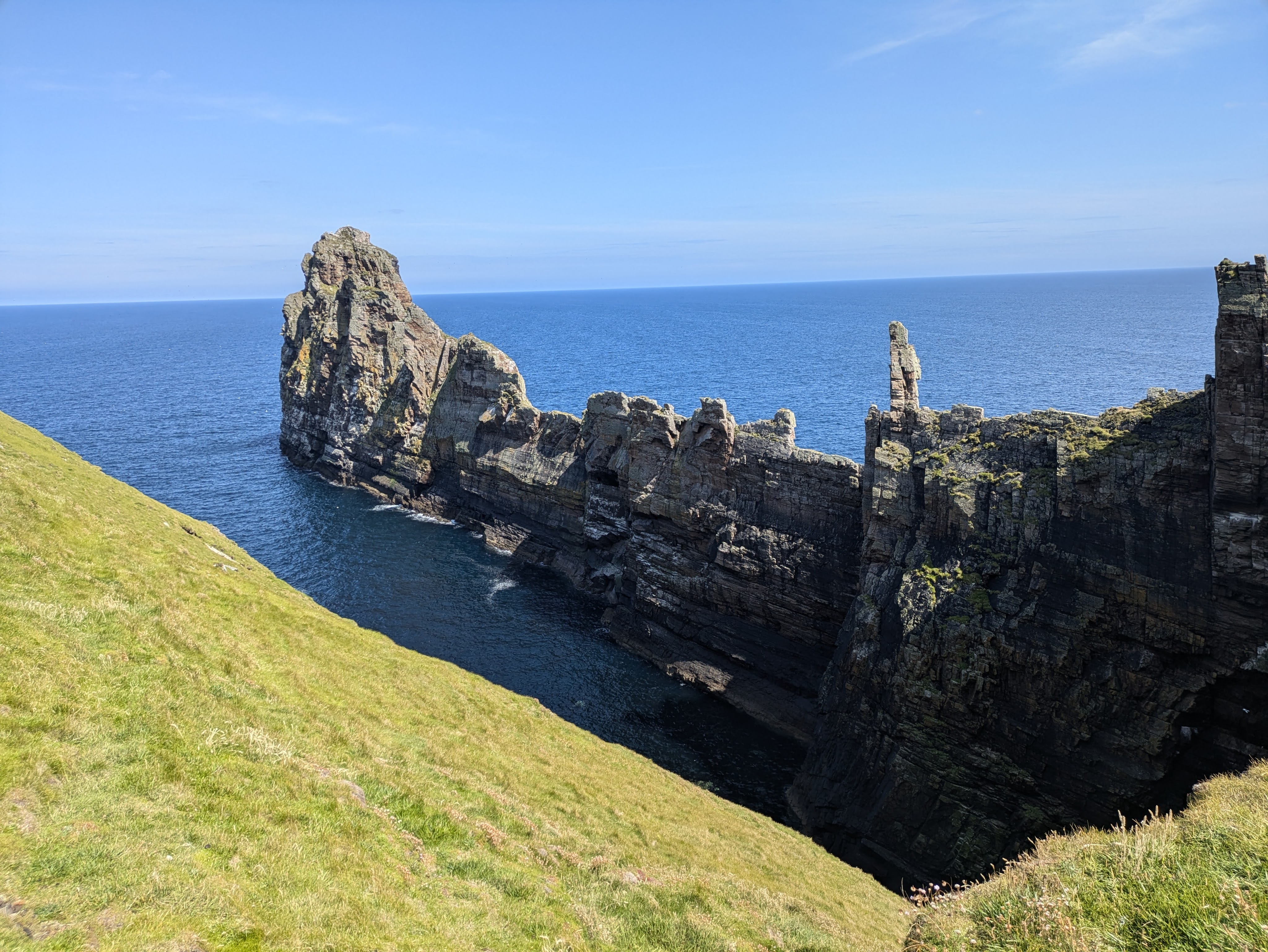
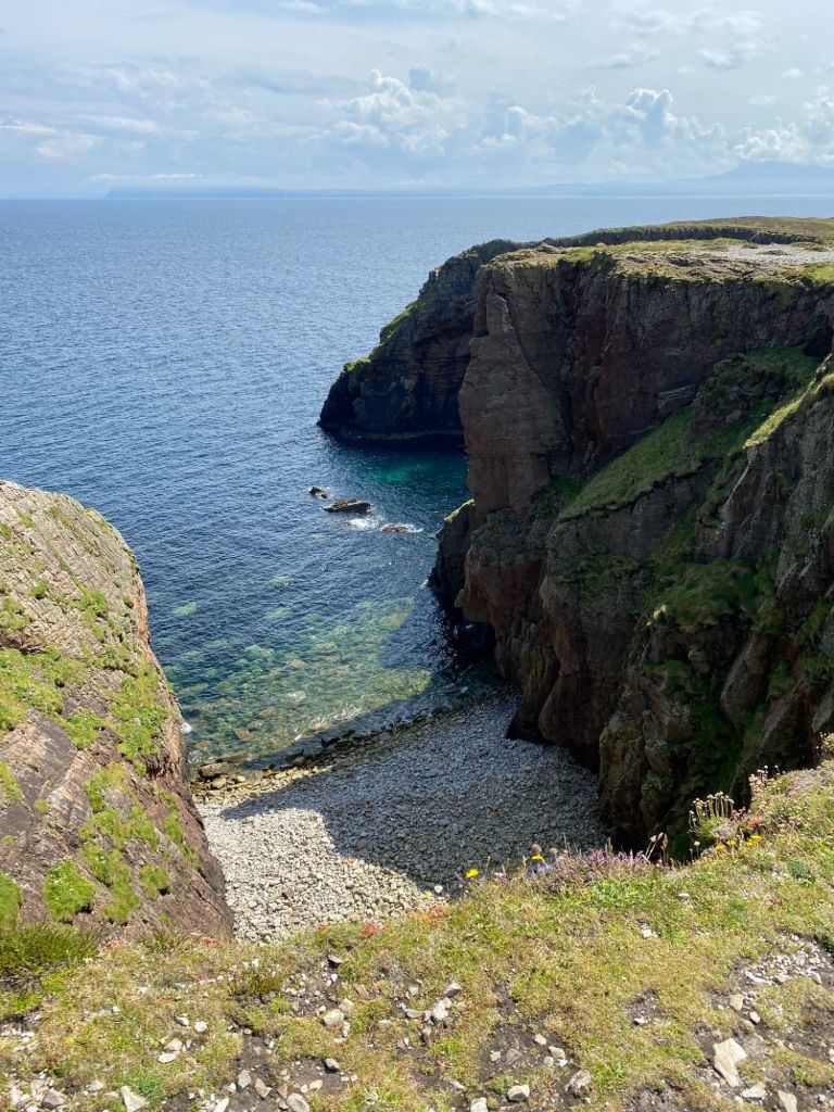
                 The sheer cliffs were even more majestic when seen from the water  with an incredible diversity of coastal erosion features – sea stacks and arches, sea caves and blow-holes and very long, isolated spurs of rock jutting out into the ocean.  From a distance, some rocky features seemed manmade but the granite outcrops are natural, formed by differential weathering of  the granite bedrock. Many of these have local ‘rock’ names (Tór Mór, The Big Key, The Anvil, The Wishing Stone, Balors Fort, Balors Prison, and The Cave, among others). Some of the names refer to the mythological Balor of the Mighty Blows – a one-eyed king whose eye was so evil that it had to be kept covered.

The seas were teeming with bobbing puffins and a few guillemots and razorbills. Earlier in the year (May and June), there were sightings of basking sharks patrolling the coastline for plankton but we didn’t see any on our trip. Although it was a calm day, the seas were surprisingly rough with surging sea-spray as we rounded the western end near the lighthouse, a tiny taste of what it might be like in stormy weather.

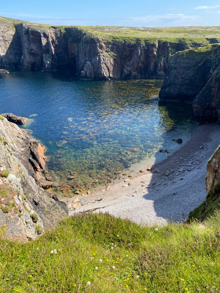
Tory has many swim spots apart from the beach at the harbour. On the east of the island at Port an Duin, right at the end of the road, two green-watered beaches frame the narrow land bridge leading out to Balor’s Fort . On the north side of the island near the hut where the artist Derek Hill painted, there is gorgeous Portín Ghlaí, which has steps cut into the hillside for easy access. Swimming every day in different spots  was ‘refreshing’, an euphemism for very cold. The water was beautifully clear, perfect for trying to avoid the jelly fish who also seemed to love the sea around the island

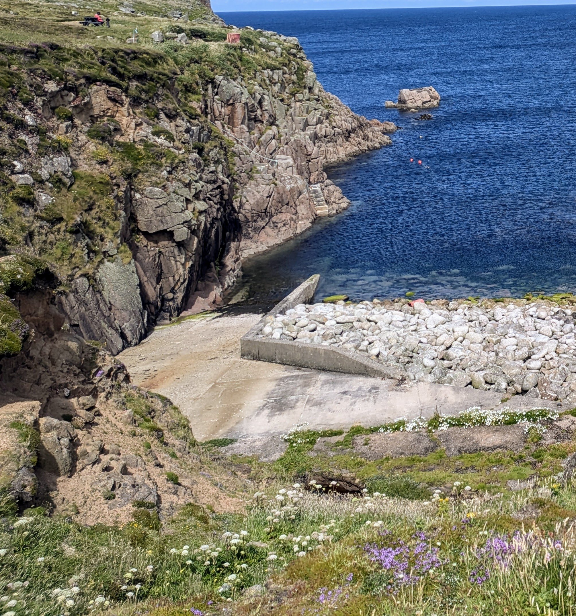
From our Airbnb near the harbour, we watched the rhythm of the island, the comings and goings of visitors and locals, the ferry bringing in people and supplies, practically everything has to be brought from the mainland. We watched crates of beer and coca cola, vegetables and washing powder, being winched from the ferry by a small crane and deposited on the pier. There is no fuel on the island, the land has long been denuded of turf  and there was little evidence of any cultivation. Fishing, except for lobster, was no longer a profitable practice as fish are relatively scare because of over-fishing in the past. Apart from the hotel which did good food at lunch and dinner time, there was the Club which served basic pub food all day- we can vouched for the pizzas which were delicious.

The King of Tory, Patsy Dan Rogers passed away in October 2018, after a long-term illness aged 74 and is buried in the churchyard. He was known to greet most ferries to personally welcome visitors to the island and is still  greatly missed

Tory is a timeless place, it feels bigger than it actually is, further away from the mainland than it actually is, steeped in history and mythology, attracting people looking for contemplation and solitude, music and art, wildlife and nature.

Truly…. Tory Island is a special place

 Slán go fóill,  Toraigh

Sunsets and Corncrakes

Tory Island – Timeless and Tantalising❤️

Colombia –  Ruins, Rivers and Desert Rain🌵

Sometimes it’s an adventure just getting to a destination.  Popayan, with its many churches and white buildings, was full of religious visitors for the many Pascal processions and Easter ceremonies but we left its busy streets to head to San Agustin, a small town not far from the border with Ecuador.  Why did we want to go to San Augustin, a place that was slightly off the Gringo Trail? Well, a young Swiss couple and an older American couple that we met along our travels, both told us that it was their favorite place in all of Colombia, so we felt that we had to go there.

We had been pleasantly surprised by the level of comfort on most Colombian buses with their  ample legroom and seat allocation ….but not on this journey. We crammed into a small bus with stained green velvet covers and set off on our 130 kms journey south to San Augustin. This bus had all the hallmarks of a well-rattled boneshaker. Caoimhin’s knees were wedged against the seat in front, my elbow was out the window so that we could both fit in the narrow seats. The journey was scheduled to take an optimistic 4 hours, but the bus-driver admitted that the time was variable and depended on road conditions, part of the way took us on dirt roads through the Parque Nacional Natural Purace, with its ring of volcanos and deep canyons.

The windows on the bus were so dirty that they were almost opaque and so the scenery, which was probably spectacular, was just a blurry green. The journey wasn’t too bad for me until we reached the uneven dirt-road part although Caoimhin had almost lost feeling in his legs. It started to rain and the driver danced the bus around the road to avoid potholes regardless of the oncoming traffic and blaring horns😲 Luggage spilled from overhead bags with the constant shuddering, some potatoes rolled down the aisle and a small dog whimpered in the arms of a man in the seat opposite us. We stopped at a roadside restaurant after the dirt road bit so that our generously proportioned driver could munch his way through soup and a hearty portion of rice and goat stew, I managed some water and a bite of cheese empanada (a kind of south American pastry). But after five and three-quarter hours, we arrived in San Agustin and creaked off the bus to make our way to our Airbnb, a steep uphill 1km from town.

San Agustín was a small traditional place where wandering goats were common in the streets and the houses were brightly painted, where farming was the main occupation…as well as chatting, they were big talkers.  It was deep in the Andes mountains, a place of steep terrain, high peaks, and yawning canyons. In many ways, it had a Garden of Eden feel, papayas fell from the trees outside our accommodation, mangoes were ripening on the bushes, there were oranges, coffee and bananas and a whole host of flowering shrubs There was rain and lots of it every day but there was also heat and sunshine with cool mornings and chilly nights…we even needed a blanket on the bed. We spent six days here and the longer we stayed, the more we liked it.

San Augustin – Goats and Graffiti

San Augustin’s claim to fame is that it has the largest archaeological area in Colombia with imposing stone statues and petroglyphs (stone carvings) as well as a whole series of burial mounds, cobbled paths and terraces. This is all that remains  of the mysterious civilizations that disappeared long before the arrival of the Spanish. Archaeologists are still puzzling over the nature and symbolism of the hundreds of stone statues scattered over a wide area. Were they making offerings, a form of protection, a bridge to the spirit world or simply pondering on life and the afterlife?

We visited an isolated site on a dramatic hillside overlooking the Magdalena River where a two-thousand-year-old petroglyph stood. Both arms were held up either in wonder at the surrounding beauty or in dismay at the destruction in the world. But when there was only an oral tradition and the original purpose is long-lost in the mists of time, everyone can bring their own interpretations. Centuries from now, will future generations wonder about us when our words are lost on obsolete computer devices?

Two Thousand Year Old Petroglyph, San Augustin.

Given the ferns and grass growing on the stones on the hillside, one has to wonder what other figures may remain hidden away from modern eyes.

One interesting point was that everyday spaces were not separated from the great tombs, people lived around the funeral centers, life and death existed in a state of constant interaction with many rituals for the living and the spirit world.  

Easter was also a time of ritual and celebration in San Augustin. The beautiful church in the main plaza was not just full on Good Friday and Holy Saturday…..it was overflowing with fold- up chairs arranged in the aisles and in rows outside the church door. A huge screen was set up in the plaza outside the church and the prayers and singing were broadcast to the town during the week. There was a candle-lit procession through the streets on Saturday evening at about 7pm but normal business continued with shops and businesses still open….people were getting their hair cut and eating in restaurants as the banners and statues passed by.

Watching the Easter Processions

This wild dramatic landscape was shaped by stone and water. Five rivers have their birthplace in the region including the mighty Magdelena, the longest river in Columbia which flows north for 1525kms until it reaches the Caribbean. We have crossed and recrossed it many times during this trip but now it was time to get into it. We booked a rafting trip for Easter Sunday to finally get up-close and personal with this important natural phenomenon.

About to get wet, Rio Magdelena

Anvil, another very talkative man, picked us up in his jeep to take us to the river on a cloudy overcast Easter Sunday morning. Our rafting companions were a lovely young Colombian couple. Luis and Dhiana. Luis was big and strong, and looked like someone who could handle the raft single-handedly. I was delighted thinking that I wouldn’t have to pull my weight on the boat but appearances can be deceiving.  Luis feared the water and had only recently begun taking swimming lessons.  He and Caoimhin started as the ‘captains,’ but after we nearly capsized at the first two rapids, Dhiana and I were promoted to the front seats and the lads were demoted and it became a less exciting trip after that as we navigated the rapids without too much incident.  But we had such a great laugh, and it was a thrilling way to view the stunning scenery and watch the flitting birdlife. Tough work on the shoulders, though.

Our next stop was Villavieje, a little town almost at sea level at the edge of the Tatacoa Desert, the second largest arid region in Columbia and a seven-hour journey from San Augustin. We arrived at about 4pm – the last section on the back of a jeep – and stepped into a dense sleepy heat. Immediately we were missing the freshness of the mountains, unused to such energy-sapping conditions after all our weeks at higher altitudes. Fortunately, our hotel had a nice pool (€25 a night including breakfast) where we cooled off with a family from Bogota and their two small boys.

The Tatacoa Desert is famous for its clear skies and is designated a ‘clear skies zone’ with observatories dotted on the landscape. Some give astronomy talks and we jumped at the chance to learn more about the night skies and to look through giant telescopes. Unfortunately, when we arrived at the observatory for the nightly tour, it was closed, maybe because of the gathering clouds and the small distant flashes of lightning.

In Colombia, there’s always a dog in camouflage
Wrinkled Gullies, Tatacoa Desert
The Grey Desert

I already said that it was one of the most arid regions in Colombia but not while we were there. The rain started at about 8pm, quickly became a downpour that lasted all night with thunder and lightning that blinked the lights several times and finally doused the power altogether. This meant that there was no air conditioning nor fans all night in temperatures that were a windless clammy 30C. It was hot rain in the desert.

The rain had eased to a drizzle the following morning when Ramiro, a tuk-tuk driver that we hired the night before, pulled up outside our hotel at 7,30am. Breakfast was the usual scrambled eggs and arepas (a corn flatbread which is ubiquitous in Colombia and eaten with every meal).  We set off on our trip to the Tatacoa Desert, which isn’t a true desert – and not just because of the rain we experienced – it is a dry tropical forest of rock with a landscape of canyons forming stunning dry red and grey labyrinths and deep gullies. Ramiro only had two words of English – ‘money’ and ‘Wow’. He loved money and Wow! was what the tourists said when they saw the desert. It was truly an outer worldly place where the red and grey colours were interpersed by the vivid green of giant cacti or other bushes. Its also home to snakes, scorpions and a wide variety of birds. We saw the birds but not the snakes or scorpions but we were delighted to see a very cute anteater.

The rain had turned the clay surface into a slippery sticky mud that caked our shoes so much it was like walking on heavy stilts. On the other hand, the clouds kept the temperatures to a manageable 30C which made walking among the wrinkled lab a more pleasant experience.

Now we have arrived in Bogota in damp drizzle and 17C for our last weekend before leaving for home on Monday evening. We are back to where we started three months ago, having experienced so much in mountain, sea and desert. This time we are staying in the city centre in a thirteenth-floor apartment, with views of the mountains and the city streets. The small apartment is a well designed, insulated box with a rooftop pool, restaurant and jacuzzi (which we haven’t used yet because of the cold and damp but the weather is set to improve tomorrow). It’s the most expensive place we have stayed  at €37 a night but then cool and trendy doesn’t come cheap🙃 It’s  very different to our usual sort of place and we are certainly older, shabbier and more disheveled than most of the young slick clientele but that doesn’t bother us in the least😀

Thanks for sharing the journey with us. Hope you enjoyed it as much as we did.

Hasta luego, amigos , 💕

Colombia –  Ruins, Rivers and Desert Rain🌵

Colombia – Coffee, Clouds and Condors

If you like to wake up and smell the coffee, then the colourful little Colombian town of Salento set amid green Andean mountains and coffee plantations may be your dream destination. Colombia has a reputation for producing excellent coffee and is the third largest grower of coffee after Brazil and Vietnam, so we were surprised to find that drinking coffee in most of the country was a real disappointment.🤨 I must admit that coffee isn’t really my cup of tea but Caoimhin, a coffee connoisseur, was disgusted with the coffee and even switched to drinking tea, water or some of the delicious fresh fruit juices. The reason for this conundrum? Apparently, all the best coffee is exported, leaving the locals with the dregs and it doesn’t help that Colombians like to stew their coffee for hours (or possibly even days) to produce a dark bitter drink called café tinto.  But not so in Salento, which has become a thriving tourist destination for coffee lovers from all over South America and further afield.

It is almost mandatory to do a coffee tour when in the town, tourists piling into dilapidated jeeps to jolt along dirt tracks to some of the numerous coffee farms doted in the picturesque hills. We opted to visit a small organic farm, Finca Don Ellias, which was both fun and educational.  All the coffee grown in Colombia is arabica, which grows at between 1000 to 2000m above sea level and gives a smooth taste while the other type of bean, robusta, grows at less than 1000m and generally produces a more bitter drink. We walked among coffee plants, their berries turning from green to ruby red, growing on a steep hillside interspersed with banana, avocado and orange trees. These other trees provide shade, absorb water, and attract flies and pests away from the coffee plants. On Don Ellios’s farm, every process was manual from composting to picking to bean separation to roasting which meant that coffee tours were as important as selling the coffee. Did you know that high roasting is often used with poorer quality bean, making coffee that it stronger and more bitter but lacking in subtle complexity? Of course, climate change is an issue here. The two harvests a year in April/May and October/November which used to be as reliable as clockwork have become problematic with changing weather conditions, the coffee berries ripening haphazardly at different times.

Grandmother’s Sock Coffee😉

 The coffee ceremony which was part of the tour was quite elaborate involving heating cups, slowly adding water which was at 80C (never add boiling water!) to freshly ground coffee placed in a cotton filter known as ‘grandmother’s sock’. After two rounds of slow careful washing and discarding the liquid, our warm cups were filled with rich smooth coffee which smelt gorgeous and tasted pretty good even to my taste buds.

Our Guide, Fernes, and Ben and Dorien, our trekking companians (Waxed Palms in background)

The other reason to visit Salento is to trek in the stunning Valle of Cocora and the Parque National Los Nevados. We went on a three-day hike with Salento Trekking which started in sunshine with a backdrop of spindly wax palms, the national tree of Colombia and the world’s tallest palm-they can reach sixty meters. Our hiking companions were a lovely young Belgian couple from Antwerp and our ‘English speaking’ guide, Fernes, whose grasp of English was probably worse than our Spanish.   Our path took us through jungle with flickering hummingbirds and brightly coloured woodpeckers, up into pine and eucalyptus forest, where the trees groaned and creaked above us as we walked and onwards into cloud forest. We hiked down to the Rio Quindio, and sweated up the other side, crossing and recrossing the same river three times on rickety rope bridges, just a few pieces of wood tied together with a plank or two missing to keep things interesting. Cloud and mist shifted over the mountains in an ever-changing pattern but became denser and damper every afternoon until all views were obscured.

On the second day, we entered the paramo ecosystem, a wildly beautiful area of high-altitude grassland above the tree-line with a host of unique vegetation where the colour palette changed from various greens to honeyed gold. There we found the stunning Frailejones, a shrub that looks like a cactus with a flowering head of miniature sunflowers. Frailejones are extremely slow growing, about a centimeter a year and we were surrounded by plants of all ages but some were at least five hundred years old. We huffed and puffed up to the viewpoint on Cerro Chispas at 4408m and were treated to a vista of cloud and mountain. Then a majestic condor soared overhead with wings spread wide, and almost take our breath away. The beautiful bird symbolises power and grace but also has spiritual significance for the indigenous people who believe that it is the wise grandfather who watches from above, offers protection and regulates the energies of the world.

 While the scenery was gorgeous and the various ecosystems were interesting, the fascinating part of trek was staying in the homes of the local people who live in these isolated Andean mountains. On the first night we stayed on a farm at 3500m, Finca Argentina. This simple homestead was merely a few connected windowless sheds where the only light came from some sheets of clear corrugated plastic in the roof. There were horses, pigs, geese, hens and a few sheep but this was an inaccessible  place without roads where the way to get in or out was by narrow mule tracks.

Animal Farm, Finca Argentina

Our welcome was lukewarm, and I can honestly say that it was the coldest house I have ever been in, a virtual wind tunnel where it was warmer to sit outside with the animals, a few pigs, hens, dogs and cats. It was the first time that we were cold since our arrival in Colombia despite wearing all the layers that we had been carrying around in our backpacks for two months.  We arrived in dense fog, cold and damp, and we stayed that way for the evening although the mists cleared and the beauty of the valley revealed itself. The only warm spot was the cozy kitchen, where firewood was burning in a huge range that also served as the cooker, and music played on a radio but the trekkers were banned from there. The cramped bedroom had no electricity and three double-bed bunks which in theory could sleep twelve but our party of five were the only ones to sleep there on lumpy mattresses that night. In fairness there were plenty of thick blankets on the beds whose questionable laundry history didn’t bother us. Caoimhin, who was wearing shorts(that’s another story), took a blanket and draped it over himself in the house but was told that blankets couldn’t be taken out of the bedroom. Dinner was tasty, vegetable soup followed by rice and veg lentil stew, but portions were meager especially for appetites made ravenous by cold, exercise and mountain air. We were all tucked up in bed by 7.30pm for warmth more than tiredness. When Dorien, the Belgian girl, got up during the night to make her way through the house to the toilet using the eerie light of her phone, she found a scene of carnage outside the bedroom door, guts and feathers and a very satisfied fat cat. I was glad that I didn’t need to use the facilities during the night because I would have probably screamed the place down.

Our second night at another farm, Finca Jordan, could not have been more different. We again arrived at about 4pm in heavy fog which lifted almost immediately.  We saw that we were surrounded by mountains, steep walls of grey rock with a waterfall tumbling down and a green field with pigs and hens and an Alsatian dog called Rocky who kept chasing a chicken despite the constant shouting of the woman of the house. There was birdsong and tumbling water and a riot of flowers bedecking the simple house, agapanthus, geraniums, roses, carnations and red-hot pokers. Our quarters were a green and blue shed with an attached bathroom and a shower with hot water…luxury after the previous night.Our host invited us into her kitchen, where we sat on a raised platform with our feet level with the stove. She plied us with coffee, tea and hot chocolate and piled our plates high with more food than we could possibly eat, brimming bowls of lentil and veg soup, rice and sliced avocado and vegetables (all of us were vegetarians). She fried long slices of bananas on her stove, covered them with slabs of her own homemade salty cheese, garnished them with spring onions from the garden. Her husband came in, put on a pair of croc slippers, and helped his wife by slicing a few veg while all the time, she talked without pause. Maybe it was the isolation that made her so chatty or maybe it was just her nature. This finca could also only be accessed by mule track, a four-to-five-hour rough trek down the mountain to get a few basic supplies.

A cosy mountain kitchen, Finca Jordan

After an ample breakfast, we headed off downhill from this haven of hospitality in a truly beautiful spot. On the way, Caoimhin got a rare sighting of a puma who stopped and stared at him on the winding stony path about a hundred meters ahead before disappearing into the trees. I got a mere glimpse of eyes and movement but that was all. The hike was very rewarding but as it was billed as a Mountain Wildlife Trek and we had an English-speaking guide, we expected to learn more about the flora and fauna. Unfortunately, our guide was not very knowledgeable, or interested in nature in any language. He just wanted to get the hike over as quickly as possible while we wanted to enjoy the enchanting scenery and spend as long as possible in nature, especially on the third day which was all downhill.

We stayed in two different places in Salento, in Hotel Natura Cocora for a few nights before the trek. This was a lovely rambling place with stunning views, a dusty kilometer and a half uphill from the town where we were welcomed and looked after by the very friendly and talkative Don Hugo, who ran the place almost single-handedly. The cleanliness was a little suspect and the bedroom with its old antique furniture was a little shabby with peeling paint but we loved the friendly atmosphere.   When we came back, we stayed in town at a fabulous hostel, Atardecer de Salento with its cats, breezy wooden balcony and proximity to restaurants and bars.

Its a cat’s life at Atardecer de Salento Hostel

After a final coffee in Salento, we were on our way south, a seven-hour bus journey to Popayan, a colonial city of churches and white buildings. Almost as soon as we stepped off the bus in the late afternoon, we were greeted by the smell of greenery, long green palm fronds and the lingering scent of incense.  We were too late to see the Palm Sunday processions, but Popayan is very popular during Holy Week, Semana Santa. Colombians flock there for the religious ceremonies, the candle-lit possessions that occur every night during Holy Week and the market stalls that are set up on many of the lanes.  On Monday evening, we joined the crowds to watch drumming bands slow- march through the ancient streets followed by numerous wooden platforms of religious icons, carried on the shoulders of men called ‘cargueros.’ The procession was long and slow, following the same route past the many churches in a tradition that has gone on continuously since the sixteenth century. Although there were several thunderstorms in Popayan on Sunday evening and Monday afternoon, the rain held off during the nighttime procession.

Popayan. the White City, La Ciudad Blanca
Holy Monday Procession, Popayan

We are about to hop on another bus to take us on a partly-dirt road to San Augustin, another small town in the Andes which is close to some pre-Columbian Archaeological sites and I’m sure that we will find some more Easter traditions.

Felices Pascuas

Gracias por leer esto

Till next time……have fun xx

A Home in the Mountains – Tranquil Location, Low Maintenance, No Problem with Neighbours😁
Colombia – Coffee, Clouds and Condors

Colombia – Tragedy and Transformation

La Alpujarra Administrative Centre, Medellin – with a green planted wall to soften the exterior.

Medellin was the most fascinating and interesting city we visited in Colombia. It is also probably the most well-known Colombian city, famous for all the wrong reasons because of the popular Netflix series, Narcos, a story of corruption, violence, and Pablo Escobar.

 Two words sum up Medellin – tragedy and transformation.  It was once the most dangerous city in the world, topping the tables for the highest rate of murder and kidnappings in the 1980s and 1990’s but now it regarded as the most fashionable Colombian city and the one with the best quality of life, attracting tourists and digital nomads.  The city sprawls along a narrow valley and climbs steeply into the surrounding mountains with a near perfect climate, often called the place of Eternal Spring.

Medellin on Map

The economy of Medellin was founded on coffee, a plant that that was ideally suited to the fertile mountainous hinterland until it was dominated by another plant, the coca plant, which also thrived in the region. Coca leaves have always been grown for small scale local consumption because when the leaves are chewed or brewed into tea, it acts as a mild stimulant which suppresses hunger and fatigue and is helpful in combating altitude sickness. Coca leaves are also the raw product in cocaine production, and this is where the infamous Pablo Escobar and the Medellin Cartel enter the picture. Escobar continues to be a controversial figure to this day, loathed by many but admired by others because of his ‘generosity’ – he gave almost 400 houses to the poor in Medellin.  But he was also directly responsible for an estimated 40,000 deaths, unspeakable violence, fear and mayhem.

We did two walking tours of Medellin, one of the downtown area and one of an district, known as Comuna 13. (There are sixteen comunas, or districts in Medellin. Comuna 13 was once the most violent district in the most dangerous city in the world, a place that was off-limits even for people living in neighboring districts. It endured sustained urban warfare and was plagued by fierce battles between guerillas and paramilitaries.

Comuna 13 sprawls upwards on a sheer hillside, a rabbit warren of narrow streets, steep steps, colorful houses and graffitied walls. Now its narrow streets and alleyways are bustling with little cafes, tourists and tour guides but the past was not forgotten. We stood in a basketball court in the centre of the Comuna where many innocent locals were murdered. Our guide told us that the brown-earth area, visible like a gaping wound on the opposite hillside was reputedly a mass grave where many of the Missing from the city were buried.

Comuna 13 – notice the bare-brown hill opposite

We were entertained by the break-dancing and hip-hop routines of groups of young local men who would probably have been involved in drugs trade in the ‘bad old days’ instead of performing for tourists.  Immersion in arts, music and sport has been one of the pillars in the transformation of Medellin and of course nothing would have been achieved without the desire of the communities to break the cycle of violence.

On a wall in Comuna 13, there was a gorgeous wall mural of a giraffe which our guide said represented the strength and resilience of the people because the giraffe has the stoutest heart of any animal relative to its size.

But how did Medellin become this beacon of hope and renewal? There is no simple answer but this remarkable transformation has included the demobilization of guerilla groups, major policy changes, the addition of social programs, and serious infrastructure investments. Our guide on the walking tour of the downtown area credited social work combined with urban architecture turning negatives spaces into positive, accessible libraries and a redefinition of education.  Places that were a no-go area when he was a teenager (he was 42) have become convivial locations of relaxation and pride with tree planting, play-areas for children, lots of seating attracting coffee-drinkers, shoe-shine boys and buskers. The Parque de las Luces was once a very dangerous area but now 300 illuminated pillars stand in the space, providing shade by day and light by night. Of course, everything isn’t perfect. The lights in the Park of Light (Parque de las Luces) were turned off last year for maintenance and still haven’t been turned on😲🕯️🕯️

One of the most famous sons of Medellin (apart from the obvious one already mentioned) is the artist and sculptor, Fernando Botero, whose distinctive work is very much in evidence around the city especially in Botero Plaza where twenty- three of his sculptures are on display.

Botera Plaza, Medellin

One of the surprises about Medellin was its fantastic public transport system which made travelling around the city so easy. There was a clean efficient modern metro system that was integrated with the bus system and the tramline. There were and cable cars, a gondola lift system that traversed the steep hills called Metro-Cable.  The locals were very proud of their Metro system, the only one in Colombia. Although it was about twenty years old, it looks as pristine as the  day it was introduced with no graffiti, broken seats or even rubbish. (The lack of rubbish was especially remarkable, as Colombians in general will fling their waster with wild abandon everywhere).  We got conflicting answers when we asked about the cleanliness of the Metro, one person told us that it was civic pride that kept it in such good condition, another said it was because there were hefty fines for littering. Whether  the approach was carrot, stick or a mixture of both, it was regularly cleaned and was a pleasure to use. We spent a couple of hours one afternoon just riding up and down on  the cable-cars and getting a bird’s eye view of the city.

Cleaning the Metro
Cable Car Views

And to really complete our enjoyment of Medellin, we found a fantastic vegetarian restaurant, Saludpan, which had European standards but at Colombian prices. This was probably the best vegetarian restaurant we have ever visited anywhere.  While it was primarily vegetarian, it had vegan options and some fish and meat choices. If you ever lucky enough to find yourself in Medellin, I’d highly recommend eating at Saludpan. We ate there each evening on our three nights in the city, breaking our own rule of never returning to the same place.

The popularity of Medellin and its agreeable climate has led to a large influx of Digital Nomads which some are calling a new wave of colonization, a soft invasion by people with computers and money.  Although welcomed by most, the influx is changing the city and driving up rents for apartments in certain areas beyond the means of locals.

Emigration was a fact of life for many Colombians for many years so the problem of mass immigration, particularly of Venezuelans who have come in huge numbers because of their domestic troubles, is a new phenomenon. Ironically, many Colombians fled to Venezuela during the dark period in their own relatively recent history so there is a strong feeling of brotherhood between the two countries.   The Colombian government in 2021 introduced a 10 -year visa for Venezuelans which gives them access to education and employment.

One of the most perplexing things we heard in Medellin was that the amount of cocaine exported from Columbia last year was three times more than it was in any year during the violent eighties and nineties. We had seen the fallow fields in Northern Colombia where once coca plants were grown and thought that this was the case in the rest of Colombia but this was in indigenous land where the Elders was strong in their opposition to coca and the drug trade. The illegal growing coca is still the backbone of many rural economies in other parts, it is lucrative, easy to grow and can produce three to four crops a year. The cartels have been disbanded and the processing and distribution have moved out of Colombia, some to neighboring Ecuador which has seen an eruption of violence this year. The situation is complex but it seems that the drug trade is alive and well in Colombia.

Guatapé, a small town about two hours east of Medellin, was probably the most colorful town we have ever seen. Everything was painted in bright colours and embellished with drawings and artistic designs. The town was on the edge of a man-made lake acting as a reservoir and was overlooked by a huge dome of granite, a landmark for miles around. This rock, called the Piedra del Penol, had an inbuilt staircase of 700 steps which was well worth the puffing for the rewarding views of the surrounding countryside, green lake-water, pine-clad islands and red soil.

Guatape – where even the tuk-tuks are brightly coloured.

The days in Guatapé were warm and overcast but it rained heavily at night turning the road outside our accommodation into a sticky red mess.

A 6-hour bus-ride on two separate buses took us through the Andes with steep drops, twisty roads, trees and flowers until we arrived to the little town of Jardin. This quiet place was nestled in the mountains amid small coffee plantations, banana trees, rivers, waterfalls and grazing cattle. The town was also brightly painted with a large flower-filled plaza and an enormous neo-Gothic church. Although there were some tourists, it had a lovely laid-back feel. We stayed in a hostel, an uphill kilometer out of town where we were woken every morning by birds knocking at the mirrored glass on our balcony door.

Jardin

We wandered around the hills and spent a glorious day chasing waterfalls on the Siete Cascadas Hike (Seven Waterfalls), a loop hike with a guide. It was challenging at times with ropes required to haul ourselves up and down some of the steep slippery slopes. It was worth every second for the tranquility, the bird song and the beauty of the waterfalls that sometimes gushed and sometimes rippled over green-mossy cliffs.

Chasing Waterfalls
A Bit of a Stretch

Lunch came wrapped in a banana leaf with some twine – rice and veg, potatoes and yucca, boiled egg and a veggie patty plus some fried banana. An enormous feast that slowed us our bodies down as we so busy digesting.

Lovely lunch on a gorgeous plate.

We have our bus-tickets booked for our next journey on Monday, a seven-hour trip south through the mountains to Salento and more coffee, where we have already organized t a three-day hike. We are not usually this organized but we are conscious of our dwindling days in this fascinating country.

Muchas gracias por leer

Feliz Dia de San Patricio  Beannachtai na Feile Padraig

Enjoy Paddy’s Day ,💚☘️☘️☘️xx

A Green Colombia ☘️
Where there’s food, there’s a dog……..
Colombia – Tragedy and Transformation

Colombia – The Lost City

Guardian of the Lost City

Everyone has heard of Machu Picchu in Peru but Ciudad Perdida, the Lost City of Columbia is far less well known despite being 650 years older and also shrouded in mystery.

Unlike Machu  Picchu, Ciudad Perdida does not have a bustling town at the base of the mountain with hotels to suit every taste and a bevy of tour buses to ferry tourists to the entrance. There is only one way to get to the Lost City in Columbia……and that is, by foot on ancient paths and tracks hiking through protected indigenous land…and it can only be done as part of an organized guided group on a multiday hike, carrying your own luggage. You have to sweat to earn the privilege of visiting the Ciudad Perdida or Teyuna as it is called by the native people. The companies offering the trip are all based in Santa Marta, a town on the Caribbean Coast so we headed in that direction.

The temperature on the overnight bus to take us from San Gil to Santa Marta was icy especially when compared with the outside temperature of nudging 30 degrees. Some passengers were draped in blankets and one woman was wearing a wooly hat covering her ears. The journey was supposed to take fourteen and a half hours but although we left San Gill almost an hour behind schedule, we still reached Santa Marta an hour ahead of time😲We were tossed and tilted on our reclining seats and would have certainly landed in the aisle if we didn’t have seat belts especially for the first few hours. Maybe it was a blessing that it was  dark and we couldn’t see the road but overall it was a relatively comfortable if chilly journey at a cost of €25 each but we saved on a night’s accommodation.

Santa Marta is a ramshackle sort of place where the drivers were unusually courteous, stopping to let us cross the road unlike those in San Gil where crossing the street was an adrenaline-fueled adventure. It’s a beach town and a busy port with a huge basilica, the oldest colonial town in Columbia (founded in 1525) and  the place where Simon Bolivar, the Liberator of South America died in 1830 of tuberculosis (although his cause of death is controversial, as most things are in this part of the world). Santa Marta could also be called the windy city, a warm gusty wind blew up in the afternoons and evenings which was quite welcome although it stirred up the rubbish and swayed the trees.

But for us,  Santa Marta was mainly our gateway to the Lost City. There is no competition between the tour companies that organize trips to Ciudad Perdida. They have all got together to form a cartel of sorts, they have the same itinerary and charge the same prices, a whopping 2 million COP per person (€500 ), a price that has doubled in the last year. As the 4 day or 5 day tour cost the same price, we opted for 5 days (we have time on our hands😄), starting the following day. If you book online, its even more expensive.

In the office of Expotours at 8.30am, a motley group of strangers looked around, assessing the people they would share the next 4 or 5 days with.  Caoimhin and I were by far the oldest, most being in their twenties and thirties.

 There were Germans, Canadians, a French woman, two English girls, a Colombian couple with their thirteen year old son but surprisingly the largest representation of any nationality was ….the Irish. There were four lads from Galway who were at the start of a 5 month stint around South America, there was Joe from Belfast and the two of us, the Elder Lemons.

A couple of jeeps took us on a bumpy ride for a couple of hours into the Sierra Nevada de Santa Marta mountains to begin our trek. After a lunch of rice, salad, beans with natural juices and an orientation talk, we were on our way with Spanish speaking guides and English speaking translators. The midday sun beat down on us and  the trail was a mixture of exposed sections where the sweat dripped from us, drenching our t-shirts and welcome shady sections through forest and a canopy of trees where we encountered a dead snake on the path.

The Trail

 The 7 Kms on the first afternoon took about three and a half hours including a stop for a swim and another to eat thick slices of  luscious watermelon, the stony paths mainly climbed upwards except the last section which was steeply downhill to our first campsite. This was an open-sided galvanized-roofed building  with a kitchen, rows of long tables for meals, rows of bunk beds, some cold water showers and flush toilets. The river, a faint gurgle from the camp was downhill where we had a swim in a refreshing deep pool before dinner and looked at the huge water spiders (apparently harmless ) which rested on the large mossy rocks.

On that first afternoon a pattern was set that would continue for the following days, the Galway lads who were all GAA players with bulging muscles, set a blistering pace, egging each other on until even the guide was a perspiring heap and the group was stretched across the trail.

Our second day began with a flickering of lights in the dorm at 5am and a lot of groaning. All the damp sweaty clothes from the day before were still wet. It had rained during the night and the air was humid. It was still dark outside and drizzly. Breakfast was papaya and melon, scrambled egg, arepas (a Colombian bread a bit like a Mexican tortilla) and sweet fruit bread.  The Galway lads were in flying form, messing and slagging each other, even at this early hour in pre-dawn darkness, woofing down any leftovers with gusto.

Indigenous People
Jungle Etiquette – stand aside for mules

We crossed into indigenous land with thicker jungle and shared the trail with the natives wearing their white traditional dress, often herding a black pig on a leash or accompanied by laden mules. We jumped when a huge jackfruit dropped from a tree and split open with an almighty splat in front of us. We passed a small village of round thatched houses with black haired children playing outside, crossed rivers and streams, swam to cool off in dappled water with leaves constantly falling from the surrounding dense foliage. It felt almost like a different dimension, another world,  with no cell phone or internet coverage – the guides communicated with each other on walkie talkies. ‘Happy Hour’, the name that the guides gave to the intense uphill stretches, began that day after a huge lunch of lentil soup with lumps of corn on the cob floating in it, veg stew (or chicken stew for the carnivores), rice and salad, finished off with a small packet of oreo biscuits. We staggered into our small camp at about 3,30 pm after a long and pretty gruelling 17 kms to be greeted by reviving coffee and hot chocolate and enormous trays of salted popcorn. The food prepared freshly by our cook, Petrona, was tasty, filling, plentiful and very much appreciated.

We slept that night in bunk beds under mosquito nets in another open-sided structure to the sound of gushing water from the river a few meters away. The guide had warned us to shake out all blankets and all clothes before putting them on……just in case. The just in case was left hanging tantalizingly in the air without further explanation.  The following morning, Joe who was in the bunk next to mine, felt something on his back when he was getting dressed. He brushed it away, but it was a scorpion which strung him on the finger. Everyone was shaking out their clothes and checking shoes after that and thankfully Joe was fine, with minor swelling and numbness.

Another Bridge

The third morning, we entered the Lost City after clambering over boulders by the river. crossing a rickety rope bridge and climbing 1200 steps to the site which is sacred to the indigenous tribes who close the site to visitors every September for the whole month to perform sacred rituals. It felt like an achievement to be there, a place that was ‘lost’ for so long, abandoned about 400 years ago and swallowed by the rampant growth of the jungle and rediscovered in the 1970s although the indigenous knew of its existence all the time. For many years after that, it was off limits for visitors, too dangerous to visit for this was drug country, an area that has known appalling bloodshed, ruthlessness, and greed. Tourism is an opportunity for change, for a new beginning and for a good livelihood not based on the cultivation and processing of drugs.

The Galway Men

  At the top of the steps, we reached the initial settlement which consisted of several large stone circles with low stone walls and some towering trees reaching to the heavens. There was an air of tranquility in this majestic setting of misty tree-clad mountains, our group were the only people there, except for birds, a trio of dogs and an army of mosquitoes, intent on breakfasting on us despite the copious amount of repellent that wafted off everyone. The site kept unfolding, becoming more impressive the further we walked until we were in front of the giant terraced platforms, that climbed one above the other, concentric circles.  There was the shadow of a huge buzzard overhead, a bird that in indigenous folklore were messengers between the spirit and the human worlds.  The sun slowly rose to warm the site and bathe the stones in warm sunlight. Soon the heat intensified, and it was time to reluctantly retrace our steps. back the way we had come, navigating the 1200 steps which seemed even steeper on the descent.

Success

On the fourth morning, the 4-day and 5-day groups parted company. The Galway lads and an Englishman had signed up for the 5-day hike but changed their minds, deciding that they couldn’t take any more with sore muscles and blistered feet.  Caoimhin and I continued for another day with the Colombian family.Our young friends  awarded us ‘warrior status’ for our endurance but the old dog for the hard road.

This fourth day with a smaller group was all about rivers and waterfalls of all types, gushing curtains of water, or water falling like gentle white rain watering a wall of exotic green plants. We crossed and recrossed the Rio Buritaca several times, more times than it seemed possible to cross the same river. We crossed with steping stones, rope bridges and once and best of all in a rope pulled ‘cable-car’, standing on a timber plank, swaying above the foaming water. The Columbian family and the guide chatted as we hiked. Although our Spanish is still not good, we can understand more than we can speak. When I couldn’t understand anything, I longed to earwig on conversations and know what people were talking about. We discovered that their chat was almost exclusively about food, what they ate and when and what they would eat again and we thought that we were missing out on deep meaningful conversations or at the very least, a bit of gossip.

On the fourth night and in a bunk bed in a camp by the Rio Buritaca (yes, that same river), we slept for a solid ten hours, both body and mind in need of rest. Our fifth day was easy, a two-hour hike through former coco plantations back to where we had started walking five days before, but we weren’t the same people, our muscles ached but our heads were full of memories of a mysterious city in the mountains that was lost and found.

What else might be out there waiting to be ‘found’?

Colombia – The Lost City

Beyond Bogota…the roads less travelled.

Leaving Bogota, we headed for the hills – literally.

Bogota is a huge city, the Uber taking us from the historic district of Candelaria drove nineteen kilometres in relatively heavy traffic to the bus station, Terminal del Norte. The bus to the little town of Ville de Leyva was surprisingly comfortable with assigned seats, plenty of legroom, air-con and phone charging points. Time is elastic here in Colombia – the bus journey was supposed to take a very precise two hours and twenty two minutes, but it was well over three hours before we reached our destination.

Strong sunshine and mountain air greeted us in Ville de Leyne, reputed to be the oldest colonial town in the country with low whitewashed buildings decorated with wooden balconies against a backdrop of brown hills.  Its claim to fame is a really enormous, cobbled plaza. The local native Indian communities used to gather there in the plaza to gaze at the heavens, a natural astronomical observatory since pre-Columban times.

Central Plaza, Ville de Leyva

We took a journey back further in time when we visited the Palaeontology Museum because Ville de Leyva also has a rich pre-human heritage. The museum recreated a very different world where giant dinosaurs roamed the land, extraordinary sea-going reptiles dominated the sea and the whole area was submerged in a shallow sea. Fossils dating back more than a hundred million years adorned the walls of many houses in the town.

After the damp coolness of Bogota we were sweating in the afternoon heat (about 24C) but many of the locals were dressed in cowboy hats, blue jeans and padded jackets. In the evening, colourful handcrafted ponchos were the clothing of choice…we weren’t temped to buy any as they wouldn’t fit into our small backpacks😁. We stayed in a family-run hostel (Hostel El Pina), great value at less than €10 a night for a room with our own wooden balcony and private bathroom.

In the coolness of the morning, we wandered around dusty roads with fields of goats, sheep, cattle and horses and also large polytunnels growing vegetables for this is agricultural country. We saw the Blue Pools(Pozos Azules)in the distance, blue because of the mineral content of copper and selenium and although not as blue as on Instagram, they were quite striking against the brown-green mountainy landscape. We clambered over barbed wire to get a closer look and after a while, we were accosted by a dodgy man looking for entrance money, Caoimhin requested he show us proof of ID which he didn’t have. A woman in the tourist office had told us that it was free to view the pools – no swimming allowed – but we had jumped over two lots of barbed wire. We turned and ran, back the way we had come, looking over our shoulders to see that he wasn’t following us.

Many of the Bus Terminals in Colombia are large modern buildings that feel like airports with rows of ticket desks, digital displays, cafes and numbered departure gates. There are many different companies with fleets of buses servicing different areas but it can be confusing to know which desk to buy the ticket for your particular destination. Some Spanish is essential as virtually no-one speaks or understands English.  It is SO easy to mispronounce the place names so even though people want to help, nobody knows where you even want to go 😲so make sure you write down the placename.

The Camino Real de Santander was on our radar before we left home. This camino is a network of stone paths, originally built by the indigenous people of the area, the Guane, to link rural villages. Winding through six remote towns & villages, across relatively untouched landscape past cactus groves, tobacco plantations and majestic mountains, it sounded just ‘our cup of tea’, a hike without the need for a guide.

We first made our way north to San Gil, known as the adventure capital of Colombia because of its extreme sports, many based around the rivers that flow both through and around the town. Walking from the bus terminal outside the town to our accommodation (Real Dreams Hostal) felt like an extreme adventure in itself. Trucks roared by in clouds of dust, buses passed within inches of us, the smell of diesel and engine oil from the garages lining the road was nauseating. In town, the footpaths were high, narrow and crowded and although there were some pedestrian crossings, cars and motorbikes didn’t stop at them. The river, Rio Fonce, with steep sides looked dirty with rubbish and very uninviting.

We left the next morning for Barichara, one of the towns on the Camino Real, and often called a filmmaker’s dream with its cobbled sloping streets, whitewashed houses with distinctive burnt orange tiles and tree and flower-filled plaza. It was declared a national monument in 1976 and we instantly loved the bustling but atmospheric feel of the place with the scent of  bougainvillea wafting around.

Barichara

Creeping out of our hotel in Barichara at 6am to start our hike, we were bleary eyed and cranky after a restless night due in part to the monumental snoring of someone who wasn’t even in a room near us….he/she was across the courtyard and on a different floor. I come from a family of snorers, but this was snoring on an epic level, sounding like a mixture of cats wailing , buildings collapsing and waves crashing. We would have felt sorry for him except we were fighting the urge to throttle him. And we had splashed out on a relatively pricey hotel (Hotel Casablanca at €27 for the night including breakfast which we didn’t eat as we left so early.)

Village of Guane

The first stage of our hike on the Camino Real from Barichara to the village of Guane, was gorgeous in soft light and birdsong, walking on a cobbled path, lined with low stone walls and with cattle grazing among the scrub, a gentle up and down walk of about 6 kms. Guane was another picture-postcard place with a central square, lots of trees, benches and sculptures and dominated by the Catholic church. After a breakfast of crispy fried eggs, sweet bread and strong black coffee, potent enough to produce palpitations, we hiked up a steep hill to begin our next leg to the town of Villenueva, past small houses with barking dogs of all shapes and sizes, who announced our presence. At the Mirador de la Virgen there were hazy views over the surrounding countryside but also a welcome breeze. Continuing uphill on dusty roads, we reached a point where we could see the welcome sight of Villanueva spread below us, about 2 kilometres away through a narrow winding path, partially through shaded wood.

Villanueva, as the name suggests, was a relatively new town and lacked the charm of the older towns of Guane and Barichara but we found accommodation in the centre of town, a cheap hotel with a friendly owner. It lacked frills and hot water, but a refreshing cool shower was just what we needed and we were the only guests so no surprise snorers. Villanueva had the usual central plaza with church and cafes and although it was well past the middle of January, the square was festooned with Christmas lights, blinking reindeers and Santa Claus. We were surprised by the number of panderias (bakeries selling breads and cakes) and also by the number of pharmacies…we wondered if there was a correlation. Half the town seemed to be having lunch in a restaurant serving the menu del dia, the usual cheap and copious amounts of food – generally soup (mainly lentil and veg) followed by a plate of rice, beans, fried vegetables and accompanied by a flattened lump of chicken or pork and a jug of juice for about €3 to €4. We joined the locals and tucked in, there was no point in saying that we didn’t want the meat, it always arrived on the plate but there was usually a friendly dog that benefitted🦮

On our second morning, our genial hotel owner was at the door at 6am to wave us off and make sure we took the right track to take us to Jordan, our next overnight stop. Walking east on red and mustard dusty roads towards the rising sun, we were accompanied by a trio of dogs for a couple of kilometres. Music blared from a small house with a couple of cattle in the field outside and a few hens pecking in the dust. In this deeply religious country,  sculptures for the stations of the Cross adorned the side of the track  to the first mirador.  The countryside gradually opened up when we reached the third mirador overlooking the Chicamocha Canyon, formed 46 million years ago.  We were wowed by the sheer majesty and the harsh beauty surrounding us.

The path from here to the small town of Jordan was all downhill but very steep. We thought that this would be easy but with heat radiating from every stone,  and without a scrap of shade or the hint of a breeze,  it was quite challenging. The surface was slippery with shale and stones and it got hotter with every step we descended until it was a baking 38C degrees on the canyon floor. We trudged on to the tiny town where workmen laying paving stones in the dense heat, were drinking Aquila beer, the same local brand that we like.  The thought of cold beer enticed us to a little restaurant with an awning where we watched a talented little girl draw on a white board and wipe away her masterpiece. The second day was only 17 kilometres, but the heat made it feel like more, much more. Our accommodation was in a small room with a fan swirling hot air all night. A Belgian couple in the hotal were also hiking the camino, the only other walkers that we met over the three days.

Chicamocha Canyon

                The third and last stretch of our hike meant crossing the bridge over the Chicamocha river and climbing up the other steep side of the canyon. It was a mere 5.5 kms but after the day before, we were determined to climb before the heat and were on the trail by 5.30am. It was much easier that expected, it was a well-established and well-maintained track  and the only way of getting between the two towns as there are no roads. We entered  Los Santos, our final destination, after a couple of hours. Los Santos was buzzing at that early hour on a Sunday morning, all shops were open, the streets were crowded and people were hanging around, drinking coffee and beer (mainly beer).

Colombia has the feel of a modern, relatively prosperous country but in one respect, it is still in the Middle Ages. People, particularly men, drink beer instead of water, copious amounts of it at all hours of the day. Beer bottles were even lined up beside workmen, working on the roads. Most of the drinking establishments are groceries as well as bars, selling everything from deodorant to cured ham. Only bottled beer is available with no draft beer, and they often have a urinal in the corner, just a cupboard without a door. I don’t know what the women are supposed to do but I’ll let you know when the need arises.

Geography dictated that the best way to get back from Los Santos to San Gil where we had left our backpacks, was to get a bus to Mesa de Los Santos where a cablecar crossed the canyon to the other side and where we could catch a direct bus to San Gil.

The cable-car ride was amazing. Everything was clearer when seen from above, the perspective of river and rock, land and bush, houses clinging like insects in impossible places, the inter-relationship of everything.  The Chicamocha River wound it’s way  like a velvet green ribbon below us and the canyon sides looked so sheer and stratified.  We had been in that landscape, almost part of it, hiked down one side of the canyon, felt the stones and gravel move under our feet, watched lizards and snakes (just one) slither across our path, felt the heat radiating from each stone, sweated each step. We had walked along the bottom in airless heavy heat, scaled the far side of the canyon at dawn. But seeing it from above, swaying in a cable car, we were truly awestruck by the grandeur of it all.

The span from one side of the canyon to the other was too wide to go directly across so the cablecars went down one side and then climbed up the other side.

I would really recommend this hike but if hiking isn’t your thing and you ever find yourself in Colombia, take the cablecar ride from Mesa de los Santos to Parque National de Chicamocha for an amazing experience…without the sweat 🤩

The Caribbean Coast is calling us now so we have booked an overnight bus tonight to Santa Marta on the coast – supposed to be a 15 hour journey but time will tell.

Thanks for reading and until next time……

Beyond Bogota…the roads less travelled.

Colombia Calling

Colombia, one of the most beautiful and diverse countries in the world,  suffers from an image problem. Mention Colombia and a few people may think ‘coffee’ but most will automatically conjure images of drugs and violence….thanks in part to the series Narcos. While there was  truth  to this,  rumour has it that things have changed in the last decade. Lets hope so as this is our first but long-anticipated visit to Colombia.

On the move – Leaving Waterford

Our Iberian Airline  plane touched down in Bogota El Dorado International Airport at the ungodly hour of  4.30am after a cramped eleven hour flight from Madrid (preceded by  a two and a half hour flight from Dublin). Immigration was straightforward (we had filled in the compulsory  Mig-Check forms online which must be completed between 72 hours and 1 hour before arrival) and a very bored official stamped our passports for ninety days.  We intend to use those ninety days to the full.

Small World

We  trudged into a very quiet Arrivals Hall while most of our fellow passengers  waited to collect luggage…we only travel with small carry-on backpacks. Our first task was to find  an ATM to get some local currency which is the Colombian Peso(COP4,300 =€1).   Bogota is huge, a sprawling city of about 8 million with a comprehensive bus system called the TransMilenio.   We decided to brave the public transport to get to our accommodation, about 15 kilometers from the airport.  Payment on buses is only by a special rechargeable card which we needed to buy. We eventually found the kiosk selling TransMilenio cards and put some money on a card using a mixture of mangled Spanish and gestures.

Google Maps was a life saver, telling  us the  whereabouts of  the bus stop and the number of the appropriate bus. We had also bought phone SIMs at another airport kiosk (we didn’t realize until later that were seriously overcharged) so we had internet on our phones. When the bus arrived, we swiped our TransMillenio  card at the turnstile inside the bus door and we were on, feeling very pleased with ourselves until a woman on the bus warned us to beware of pickpockets.

Candalaria, Bogota

Traversing Bogotá pre rush-hour took at least an hour and involved two buses. We travelled through quiet shopping streets with the usual international stores(like Ikea) past  skyscrapers and parks. A flower market was  just opening it’s stalls and a few homeless were stirring under blankets of cardboard. There was graffiti and wall murals everywhere we looked.  It was a bright chilly morning, about 7C,  and there was a soft light on the green  hills that surround the city….Bogota is built in a valley with buildings spawling up the steep slopes of the hills. Our phones buzzed,  Google Maps telling us where to get off and we stepped bleary-eyed and jetlagged onto the colourful streets of Candalaria, the old historic part of town with its brightly-painted, 300 year old houses, cobbled streets, cafes, churches and…. steep hills. That first morning, we struggled to a lovely apartment that we had booked for three nights((Morph, €33 a night) feeling a little woozy,  gasping from tiredness and altitude….Bogota is at 2600m. But soon we discovered the grocery/bar where the locals hung out and the beer was €0.60 a bottle🍻 There was a strong police presence in the area with officers on many street corners with big muzzled rottweilers. Despite that- or maybe because of it – the area felt calm and safe.

 Graffiti is such an integral part of Bogota that we took a Graffiti walking tour. Graffiti was decriminalized in 2011 and since then,  Bogota’s walls and buildings are an ever-evolving canvas of brush, paint, marker and stencil, most spectacularly beautiful, some political and others simply art for art’s sake. One recent mural of a injured child planting green shoots was a comment on Gaza.

Street Art, Bogota
Gaza Comment

Gold is also a part of Colombia, historically, symbolically and culturally. The indigenous people believed that gold was a gift from the gods and wore it to celebrate the gods, not for personal wealth. The invading Spaniards had other ideas, dazzled by the dripping gold of the natives and driven by insatiable greed, they all but destroyed the native culture.  The legends of El Dorado, the country paved with gold, originated in  Columbia. We visited the Museo del Oro( Gold Museum) four floors of the most gorgeous jewelry and artwork.

In Bogota, the weather is changeable. The clouds can descend on the hills like a veil, hiding the church at the top of Mount Monserrat, a city landmark. In the chilly breeze, we pulled on jackets but the next minute we could be blinded by the blueness of the sky and applying sunscreen.

 On our third morning in Bogota when we were no longer panting going uphill, we decided to hike Monserrat which is at 3150m. We weren’t alone. The steep path was crowded with families, couples, groups of teenage boys playing competing music on their phones and some very fit runners….a very popular activity on a Saturday morning. We required a lot of stops along the way so either we weren’t as acclimated as we thought or maybe not fit .We were greeted with surprisingly hot sunshine at the top. We rested on the steps outside the church until our ears were blasted by more loud music. We went into the church to get away from it…and then realized that it was coming from the church, telling people that Mass was about to begin. The large church was packed, standing room only.

The cable car seemed a good alternative route down for the views. Unfortunately, the cable car was sardine-tin crowded on a Saturday morning and I was squashed behind a party of German giants which gave me VERY limited views but the occasional glimpse of trees was nice.

Cable-car, Monserrst, Bogota.

Did you know that Colombia is famous for cycling? Even more surprising, Bogota closes 100 kms of it’s streets to motorized vehicles  on Sunday mornings,  leaving the street free for cyclists and pedestrians. Nor is this a new ‘green’ initiative, the first ciclovia happened in 1974.


As I’m writing this, there’s a band playing on the street outside and a trio of acrobats in the Square. We have just strolled around the Candalaria area with it’s vibrant Sunday afternoon street life, our veins fizzing from strong coffee.

Tomorrow, we will leave Bogota and head north …..not quite sure where yet. Some research needed…..🤔


Thanks for reading. 

Bogota…where the skyscrapers are colourful.


Colombia Calling

Camino del Faro- The Lighthouse Way

Mention the words ‘Camino’ and ‘Spain’ in the same sentence and most people will think about the Camino de Santiago, the incredibly popular pilgrimage way of St James. But there are others far less trodden paths🥾.  We have just completed the spectacular Camino del Faro (The Lighthouse Way), a 200 Kms trek in Galicia along the Coste del Morte (Death Coast), linking the towns of Malpica and Finisterre and walking from lighthouse to lighthouse.

Camino del Faro (Lighthouse Way)

Our journey began with a late Ryanair flight from Dublin to Santiago de Compostela, arriving at about 11.30pm. Yellow bus signs on the ground at the airport Arrivals directed us to a bus stop outside the terminal where the 6A took us to the centre of town in about 35 minutes for one euro😃. The streets were quiet and shuttered and a couple that we saw in the airport queue, followed us to the same hotel, Hotel Windsor, a no-frills place but very clean, very central with loads of hot water. 

The following morning we discovered that the buses to Malpica, our starting point, were infrequent with just two buses a day…we had  missed the first one and the next one was at 1pm. We wandered around the Cathedral area which was crowded with tourists, walkers,  pilgrims and the ubiquitous shells from jewelry to tablecloths to masonry etchings – pilgrimage is big business in this part of the world. Confessions were available in multiple languages but few were availing of the opportunity.

Malpica♥️

Getting to Malpica involved a change of bus at Carballo but both buses were comfortable, efficient and cheap with the two and a half hour journey costing less than a fiver each and we paid the drivers on the buses.  Malpica was a surprise…a really gorgeous little town that we had never heard of until we investigated this trek, with a prom that curved around s turquoise bay.  We booked into JB Hostal with a large sunny seaview room, 55 euros a night. (In Spain, hostals are guesthouses, different to hostels with dormitories). The seafront was teeming with surfers and little cafes with cold beer and good wine🥂.  The beach was dangerous for swimming so we wandered down to the pretty port area to find the start point of our camino. This  first lighthouse was a disappointment…hardly visible and behind a big seawall with a No Trespassing Sign (in Spanish) – very little English spoken or understood here.

Malpica Port

It was barely light when we crept out of our guesthouse at 7.45am without breakfast(not included). We were smothered in sunscreen,dressed in shorts and carrying all our belongings on our backs. Apart from a few dog walkers, the whole town seemed to be sleeping. We passed a holy well, pristine white-sand beaches and a church on a cliff, stark against a backdrop of  barbie- pink heathers. We walked to the incessant sound of the restless sea, relatively benign and blue on this gorgeous early September. day.  The first restaurant we came too -after 3 hours walking – was closed until 1pm. Although we had some stomach rumblings, we pushed on as we didn’t want to hang around for 2 hours until it opened. We didn’t know then that we wouldn’t find another one😬

Leaving Malpica, Day 1
Water along the Way

There were chest high ferns and boulders like giant marbles to clamber over in search of the green dot, which denoted our path but which was sometimes quite elusive🟢. At a little port area where we sat to have a meagre snack of nuts and bananas, a light drizzle started, welcome and cooling at first until it got heavier and became  a drenching deluge.  There was neither shade nor shelter. The wind howled around Nariga Lighthouse, tossing rain and foam at us from all directions. We trudged along like drowned rats until we reached Ninons Beach, a secluded remote beach and the end of Day 1. We hadn’t any accommodation booked,  assuming that we would find something along the way but the coast was  isolated…we didn’t meet a soul that first day in 22 Kms of hiking. We decided to call a taxi to take us back to Malpica. That’s when we discovered that there was no signal in Ninons😁 so we squelched another kilometer uphill to make the call. The phone signal kept dropping but a taxi materialized out of the rain…like an apparition because Caoimhin wasn’t sure that he had got the message through. Back in Malpica, our shoes were sodden and everything we were wearing dripped a muddy trail up the stairs. Although we had rain covers for our backpacks, we discovered that  everything in them was also wet.  But after a hot shower, the sun came out, the outside tables were wiped down, the wine was still cheap and I ate a basket of bread and probably the best mussels I have ever tasted😍.

 Day 2 started with wet shoes and damp clothes. We had bought a lavender spray in the Chino shop to mask the stench of damp but it was so synthetic that it smelt almost toxic. Our taxi dropped us back to Ninos Beach where we climbed through gorgeous eucalyptus forests (their scent wasn’t strong enough to mask the lavender 😏). Shining granite rock shimmered in the sunshine along this walk to Ponteceso with many diverse landscapes from rocky cliffs, salt marsh, sand dunes and river estuary, a haven for birds. This stage was beautiful but long (almost 27 Kms). When we came to the seaside town of  Corme at the 17kms mark, we were ready for a break.The first place didn’t do food until evening time so we had a cold beer and moved on to another establishment where we ate fish salad and patatas bravas. Although the sun was hot and relentless for the last stage we still managed to get wet feet, walking on boardwalks submerged by the incoming tide along the estuary. 

Roncudo Lighthouse, Day 2

When we reached the hostel, my feet were shriveled and blistered, I had  a welt on my hand from clutching the walking stick and an ache across my shoulders from the backpack. This Camino began to feel like a pilgrimage of sorts. In a local bar, the friendly owner insisted on plying us with free tapas which we were almost too exhausted to eat. But things improved from this point and day 2 of multi-day hikes is well- known to be the tough one.

We discovered that socks could be dried very effectively by wrapping them around a hairdryer sprout ( if you were fortunate enough to have access to a hairdryer) and stuffing shoes with old newspapers(periodicos viejos) helped a lot. Comped plasters and Vaseline were a balm for feet and a hotel in Laxe with a bath worked magict to ease tired muscles.  The hikes became easier as our bodies – and minds-  adjusted.  We carried food supplies, pockets stuffed with bread and cheese,  a supply of biscuits, bananas, nuts and chocolate and an emergency can of sardines. Most days the only people we saw were solitary locals, clambering over rocks far below us, splashed with foaming water, gathering gooseneck barnacles from the heavily oxygenated waters – a treacherous occupation. We always trekked in hope of a cafe. A local woman, who was hanging out her washing, offered us life-saving coffee  when we were disappointed yet again that a cafe/bakery marked on our map was closed. This lovely woman filled our water bottles and even offered us beer and food. Wonderful hospitality. 

 Sometimes our Camino veered inland where we walked through woodland to the sound of birdsong, hiked by streams where old water mills were covered in moss and past high villages where stone houses looked abandoned surrounded by fields of withering corn and orchards of dripping fruit. But mainly our path hugged the coast faithfully, often just a narrow ribbon clinging to steep cliffs with dizzying drops. 

The Costa del Morte is not called the Death Coast for nothing. The coast was littered with stone crosses, bargains made with the heavens or erected as platitudes to the sea, or places to remember the dead. There were  tales of shipwrecks, drownings, smugglers and pirates. On a lonely headland,  the doomed victims of ill-fated ships were buried in a place called the English Graveyard.  A stunning sculpture near the Lake Lighthouse of a woman gazing out to sea, captured the anxiety and agony of waiting. An isolated church on a hilltop was a place where local women used to go in times of storm to pray for a change of wind to bring their men home. 

As we hiked further west, the coast became wilder and even more remote. On our fifth day,  after days of sunshine, the forecast was bad and didn’t disappoint. The cold blue-green of the sea, mesmerizing and dangerous, turned an ominous gray. We watched two surfers paddling on their boards out to churning waves that crashed on jagged rocks and marveled at their stupidity -so small and insignificant. Even the seagulls were sheltering from the elements, hunkering down on the beaches. The wind became ferocious,  the rain came at us sideways and we could barely stand upright but we got a tiny glimpse of what this coast might be like in bad weather and it was awe-inspiring.

After six days walking, we arrived in Muxia, a pretty little town with safe beaches, a lighthouse and a place of legends. It was here that the Virgin Mary arrived in a stone boat to encourage Saint James to continue in his work.  Large stones near the church were reputed  to be part of Mary’s boat and to have magical properties.The Barco festival was starting the following day so we decided to take a rest day and stay an extra night. Muxia  is on the Camino de Santiago so was busier than anywhere else we stayed. We discovered that Spanish festivals only get going around midnight and continue until at least 5am and nobody even thinks of eating until 10pm. Unfortunately, we couldn’t stay awake for much of the festivities🥳. Muxia was badly affected by The Prestige disaster in 2002, which leaked thousands of litres of crude oil into the sea all along the coast here.

Although it hardly seemed possible, the scenery got even more spectacular as the days progressed. The penultimate day was the ‘queen of the mountain stage’ with steep climbs and stupendous views. We trekked to Tourinan Lighthouse, which was supposedly the most westerly point in Europe and got the last rays of sunlight in the Spring Equinox. On the eighth and final day, it almost felt as if we were in the landscape, part of it and not just looking at it, at one with the sea and the wind (or maybe that was just exhaustion or relief with our end goal within reach 🙏).

Fisterre, the end of the known world for the Romans, was a strange little town, full of weathered people with walking sticks, limps and flip flops. It was the endpoint for pilgrims on the Camino de Santiago as well so it didn’t have to try very hard to attract visitors. But the landscape around the Finisterre lighthouse, a couple of kilometers hike outside the town, was worth the entire Camino, a fitting place to finish. This was a wild landscape of mysticism, of drowned cities and submerged mountains, of altars to the sun and timeless rituals with tales of sterile couple becoming fertile after sleeping on one of the large rocks on the hill overlooking the sea and healing miracles.

So we made it, 200kms in eight stages. We carried out own packs and booked our accommodation as we went along, usually walking from stage to stage but getting taxis to our accommodation if we couldn’t find anything near the end stage.  The Camino del Faros was probably the most spectacular hike that we have ever done.  It was quite challenging at times (more than we had anticipated but we hadn’t done a lot of training). Each day on its own would not have been difficult but the cumulative nature of hiking relatively long distances day after day exerted a toll.  The bigger the challenge, the greater the reward 🌞 and  the rewards were huge. There were no stamps to collect in a pilgrimage passport, nothing to ‘prove’ that we had trekked along the way. The benefits of this Camino were all internal – solitude,  genuine communing with nature and an appreciation and respect  for the power of the sea -to mould and erode, to give bounty and to take it away. If you like the great outdoors, like to go a little off the beaten track, then this is the hike for you.

The end of the world 🌍
The End – Faro de Finisterre

Link below to a fabulous website with lots of details.

Camino del Faro- The Lighthouse Way